E 4 CHINGFORD & HIGHAMS PARK.
ART & HISTORY SITES ON FREE PUBLIC VIEW
Various suggestions have been made for the origin of the name Chingford. Most agree that it was near a ford over the river Lea. The most plausible explanations for "Ching" are:
|
PUT MOUSE OVER  TO READ NAME
CLICK ON FOR PHOTO & EXPLANATION.
CONTENTS | ||
| 1. Chingford Mosaic | 2. All Saints Church | 3. Barometer |
| 4. Butler's Retreat | 5. Cartoon Characters | 6. King Charles II |
| 7. Corbis Cottage | 8. Queen Elizabeth's Hunting Lodge | 9. Fleeing Woman |
| 10. The Fountain | 11. Friday Hill House | 12. Decorated Gable End |
| 13. Gargoyle | 14. Millennium Clock | 15. The Obelisks |
| 16. Our Lady of Grace, R C Church | 17. The Park Gates | 18. Peace Year |
| 19. Pimp Hall Dovecote | 20. Chingford Mill Pumping Station | 21. Railway Signal Levers |
| 22. Signal Box | 23. Sunnyside Lodge | 24. Tao Column |
| 25. Old Toll Bridge | 26. Wood-clad Cottages | |
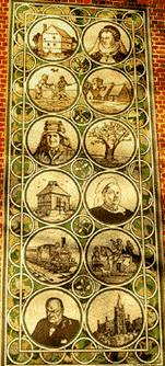 |
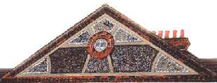
The Chingford Mosaic. | ||||||||||||
On the front face of the Chingford Assembly Rooms in Station Road, E4. This large mosaic depicts some important people and buildings connected with the area. They are:-
Queen Victoria, the tree and the train are featured because in 1882 she visited Chingford by train to declare that Epping Forest was from henceforth to be for the enjoyment of all. From Norman times it was a royal forest intended solely for royal hunting trips. By the nineteenth century, local landed gentry had taken to fencing off certain areas and adding them to their estates. But in 1878, parliament passed the Epping Forest Act which put a stop to the practice. Churchill was the local MP for many years. (See No. 1. on Map ) Artist: Wallscapes. Date: 2000 |
|||||||||||||
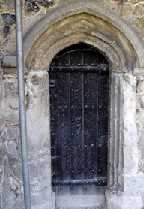 |
All Saints Church. | ||||||||||||
Old Church Road. This is the church that gave it's name to the road. The illustration shows a small door in the north wall. The wall may date back to the 12th century, and the door is only about four and a half feet high. So either all members of the congregation were exceptionally short or else they all had to duck when using this door. There is a bigger door further along the same wall. At the present (2005), the church is undergoing extensive restoration, which explains the scaffolding pole in the picture. (See No. 2. on Map ) |
|||||||||||||
 |
Barometer. | ||||||||||||
Over the shops in Albert Crescent, Chingford Mount The barometer is shaped like a clock face. It is supported on either side by two figures in the 1930s Cinema style. Another pair of similar figures supports a clock tower over a second block of shops in the crescent. (See No. 3. on Map ) |
|||||||||||||
 |
Butler's Retreat. | ||||||||||||
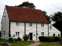
In Rangers Road, adjacent to Queen Elizabeth's Hunting Lodge. This nineteenth century timber building was originally a barn. However in 1891 members of the Butler family turned it into a caf�. (See No. 4. on Map ) |
|||||||||||||
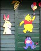 |
Cartoon Characters. | ||||||||||||
Ridgeway Park off Church Road, E4. These are decorating the hut where putting green and the tennis courts are booked. The model railway is further into the park. (see Fleeing Woman ) (For cartoons see No. 5. on Map ) |
|||||||||||||
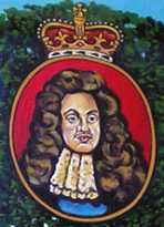 |
King Charles II. | ||||||||||||
Sign in front of the Royal Oak Public House, Kings Head Hill. In 1651 after losing the Battle of Worcester in the English Civil War, Charles hid in an Oak tree before escaping to France. The tree became known as the Royal Oak. Charles II (reigned 1661 � 1685) was also known as the Merry Monarch. This may have been because of the contrast between his reign and Cromwell's austere Puritan administration. However, it may have been because of the string of mistresses which he kept. Probably the best known of whom was the orange-seller Nell Gwyn. She later went on to be mistress of Charles Sackville, (Lord Buckhurst, Earl of Dorset), whom she sometimes referred to as her Charles the second. (See No. 6. on Map ) |
|||||||||||||
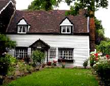 |
Corbis Cottage. | ||||||||||||
The Green, Chingford. This picturesque cottage may possibly go back to the 17th century. It is a reminder that this area was once a rural Essex village before the railway arrived and it became a suburb of London. (See No. 7. on Map ) |
|||||||||||||
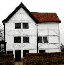 |
Queen Elizabeth's Hunting Lodge. | ||||||||||||
Rangers Road, Chingford. There is car park opposite. Although it now bears Elizabeth's name, it was her father Henry VIII, who built this in 1543. Being tall, it commands a view over the neighbouring forest, allowing occupants to watch the progress of the hunt. The building was originally known as a "standing" and had no roof. The timbers of the first floor were built sloping outwards to let the rain water drain off. This Tudor half-timbered building is open to the public on some days and admission is free. The top two roundels in the Mosaic. show Queen Elizabeth on the right and the lodge on the left. (See No. 8. on Map )
|
|||||||||||||
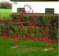 |
Fleeing Woman. | ||||||||||||
Ridgeway Park, off Church Road, E4. The Female figure in metal depicted in flowing outlines is situated on a grass lawn near to the toilet block. This park has a permanent small gauge railway track, and on Summer Sundays members of a local engineering club bring their model steam locomotives and give rides to children at a modest cost. There are a few parking spaces in the park. (See No. 9. on Map ) Artist: Jack Gardner. 1997. (See also "Lotus", "Tao Column" and "Allum" by the same sculptor) |
|||||||||||||
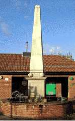 |
The Fountain. | ||||||||||||
At the junction of Old Church Lane and Hall Lane, Chingford Mount. (See No. 10. on Map ) |
|||||||||||||
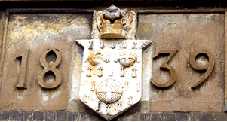  |
Friday Hill House. | ||||||||||||
Simmons Lane. The present building dating from 1839 was a manor house built and owned by Robert Boothby Heathcote, who was both the lord of the manor and rector of the local church. It was he who paid for the building of the church of St Peter and St Paul in Chingford. He is buried Boothby family vault in All Saints churchyard (Chingford Old Church), Old Church Road. The vault was purchased by Robert Boothby (died 1733), who lived in the previous manor house on this site. The present building is now used as a further education centre. The upper picture shows the crest over the front door. (See No. 11. on Map ) |
|||||||||||||
 |
Decorated Gable End. | ||||||||||||
The Chingford Dental Laboratories, on the corner of Ainslie Wood Road and Chingford Mount Road. This is not a mosaic using the normal tesserae. Various materials have been used for colour and texture variation, ranging from pebbles to tiling. (See No. 12. on Map ) Dated 1909. |
|||||||||||||
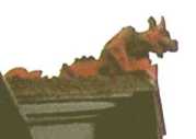 |
Gargoyle. | ||||||||||||
On the roof of the Queen Elizabeth Public House, Forest Side. For those customers who expect to see pink elephants when they over imbibe, it must be a sobering shock to see fearsome red demons looking down on them. (See No. 13. on Map ) |
|||||||||||||
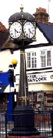 |
Millennium Clock. | ||||||||||||
Near Highams Park Station, at the junction of Hale End Road and The Avenue. This pseudo-Victorian clock is described on the base as having been erected by Waltham Forrest to celebrate the millennium. (See No. 14. on Map ) Date 2000. |
|||||||||||||
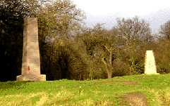 |
The Obelisk. | ||||||||||||
Situated on Pole Hill in Epping Forest and accessible from Pole Hill Road. This was originally set up by John Pond in 1824 and was used for lining up the Bradley Telescope at the Greenwich Observatory. (See under St Mary's Church, E11 for more on Bradley) However in 1850 a new Airy telescope was installed which was six metres west of the original so the new instrument could no longer line up on the old marker, and a new smaller obelisk was put up. Also, due to the movement of the earth's tectonic plates, the meridian moves a fraction of an inch each year. The Ordinance Survey maps for Britain were based upon the old Greenwich meridian, but at the realignment of 1850, the calibration of these maps was not changed. So this stone can still stand proud, because it helped to establish Britain's present mapping system. It was on west side of Pole Hill that T E Lawrence (Lawrence of Arabia) once lived. His likeness is the third down on the left column of the Mosaic. (See No. 15. on Map ) Date: 1824. |
|||||||||||||
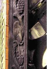 |
Our Lady of Grace & St Teresa of Avila. | ||||||||||||
The Roman Catholic Church on the corner of Station Road and King's Road. The porch over South door on the King's Road has some wood carvings of animals and fish among vegetation. The dark weathered wood does not show up the carvings very well. The church should not be confused with larger Church of England building on the facing corner. (See No. 16. on Map ) Carver: Don Potter. 1956. |
|||||||||||||
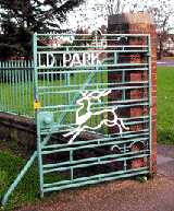 |
Park Gates. | ||||||||||||
Entrance gates to Mansfield Park in Church Road near the mini roundabout. Visitors should not expect to find any deer in the Park, but in the field at the end of the laid out part visitors will find a panoramic view over the reservoirs in Lea Valley. The ground in this field has a number of parallel ridges, which are probably signs that it was used for strip farming from the middle ages until the early nineteenth century. (See No. 17. on Map ) |
|||||||||||||
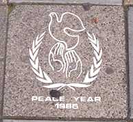 |
Peace Year. | ||||||||||||
Paving stone near the traffic lights at Chingford Mount on the corner between Church Road and New Road. It is dated 1986. The photo shows the word peace partly obscured by chewing gum, which is rather symbolic when one thinks of the amount of fighting and violence that has taken place in the world since that year. (See No. 18. on Map ) |
|||||||||||||
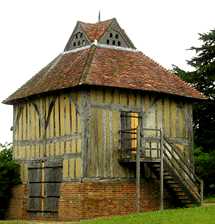 |
Pimp Hall Dovecote. | ||||||||||||
In a green area at the bottom of Friday Hill. It is possible to get a good view of this by entering the Pimps Hill Nature Reserve. To find this, go down the turning by 48 Kings Road, and go past the entrance to Kings Road Recycling Centre, facing you is a gate to the nature reserve. This Tudor style dovecote dates from the sixteenth century. At that time, pigeons were kept and fattened up for eating. The dovecote, which had nesting space for 250 birds, belonged to Pimp Hall (Originally Pympe's Hall), one of three manor houses around Chingford. In 1838 the estate was taken over and became part of the Chingford Earls estate. The farmhouse associated with it survived until just before World War II. This dovecote is depicted in the Mosaic. It is the fourth down on the left hand side. There is a local legend telling how on one occasion Charles II was out hunting in Epping Forest and was caught in a snowstorm. He took shelter in Pimp Hall and was so delighted with the food offered him that he jocularly drew his sword and knighted the joint of beef declaring that it was now Sir Loin. Either this story caused the nearby pub on Friday Hill to called "The Sirloin or vice versa. (See No. 19. on Map ) |
|||||||||||||
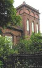 |
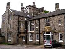
Chingford Mill Pumping Station. | ||||||||||||
Lower Hall Lane. Dating from 1895, this pumping station was built by the East London Waterworks company. It is now a Grade II listed building. The road outside goes over a small bridge, which once used to be a toll bridge, and which has an interesting old notice on it. (See No. 20. on Map ) |
|||||||||||||
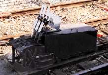 |
Railway Signal Levers. | ||||||||||||
Between the rails at Chingford Station. These old hand levers used to change the signals/points using connecting rods. The Great Eastern Railway reached Chingford in 1878 and it still remains the terminus of the line. That explains why these levers are sited between the tracks. (See No. 21. on Map ) |
|||||||||||||
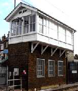 |
Signal Box. | ||||||||||||
Overlooking the level crossing by Highams Park Station. This signal box was built by the London North Eastern Railway in 1925. It was saved from demolition in 2002 as it is almost the only one of its type now surviving on this line. (See No. 22. on Map ) Date: 1925. |
|||||||||||||
 |
Sunnyside Lodge. | ||||||||||||
On the corner of Woodbury Way and Kings Head Hill. This house was originally the gatekeeper's lodge of a large nineteenth century house called "Sunnyside". (See No. 23. on Map ) |
|||||||||||||
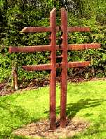 |
Tao Column. | ||||||||||||
Memorial Park, Chingford Mount Road, by the pond near the tennis courts. This iron sculpture shows signs Chinese influence. Taoism, Confucianism and Buddhism are the three major religions of China. The word Tao means the right path in life. (See No. 24. on Map ) Sculptor: Jack Gardner. 1991. (See also "Fleeing Woman", "Lotus" and "Allum" by the same sculptor) |
|||||||||||||
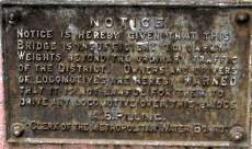 |
Old Toll Bridge. | ||||||||||||
Lower Hall Lane almost opposite Chingford Mill pumping station. Near the end of this is a small road bridge which was once a toll bridge. On this there is a rusty old sign dating from c. 1900 which states:
Presumably he feared that it might collapse under the weight of the heavy steam driven vehicles then beginning to appear. (See No. 25. on Map ) |
|||||||||||||
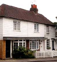 |
Wood-clad Cottages. | ||||||||||||
Numbers 3 � 7 Kings Head Hill are wood-boarded cottages dating from the 19th century. (See No. 26. on Map ) |
|||||||||||||
 www.aboutbritain.com/QueenElizabethsHuntingLodge.htm
 OTHER AREAS COVERED:-
|| Beckton || Bethnal Green || Blackwall || Bow || Bromley-by-Bow || Canary Wharf || Canning Town || Chingford || Cubit Town || Custom House || East Ham || East India Dock || Forest Gate || Higham's Park || Leyton || Leytonstone || Limehouse || Little Ilford || Manor Park || Mile End || Millwall || North Woolwich || Plaistow || Plashet || Poplar || St George's || St Katharine Dock || Shadwell || Shoreditch || Silvertown || Snaresbrook || Spitalfields || Stepney || Stratford || Upton || Walthamstow East || Walthamstow Village || Walthamstow West || Wanstead || Wapping || West India Dock || Whitechapel || Woodford || |