MILE END
| The name is derived from the area being one mile from the gates of the city of London. With arrival of the tube, underground stations sometimes were given names, which were not always accurate. In the 18th century, the area round Brick Lane was known Mile End New Town. The station in Mile End Old Town was called Stepney Green, while the next stop to the East was called Mile End Station. In the popular view, therefore, today Mile End is thought of as being at least one mile to the East of its original position. Perhaps the station should have been called Two Mile End. |
 TO READ NAME ~ CLICK FOR PHOTO & EXPLANATION.
CONTENTS |
||
| 1. Stanley Atkinson | 2. Dr Thomas Barnardo | 3. Central Foundation School |
| 4. Clock Tower | 5. Cycle Mile Marker | 6. Draper's Hall Sculptures |
| 7. First Flying Bomb | 8. Firewatchers' Memorial | 9. "Fish" |
| 10. The Gas Works | 11. George V Gardens | 12. Green Bridge |
| 13. Guild of Handicraft | 14. Innocence of George Davis | 15. "Knowledge" |
| 16. Landmarks | 17. Library Ceiling | 18. The New Globe |
| 19. Pointing Figure | 20. Post Box | 21. QMC, Eric Gill Sculptures |
| 22. Ragged School Museum | 23. "Sacrifice of Isaac" | 24. Mile End Park Stadium |
| 25. Sculptural Seating Installation. | 26. Lord Tredegar | 27. Workhouse |
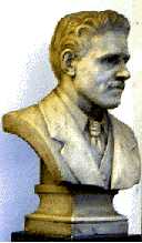 |
Stanley Atkinson | |
This bust of Stanley Bean Atkinson (1873-1910) is in the public library in Bancroft Road, on the first floor landing facing you as you go up the stairs. For further details about Atkinson, see also Atkinson Memorial erected in his memory. (See No. 1. on Map) |
||
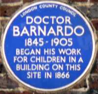 |
Dr Thomas Barnardo | |
On the wall over a fish & chip shop in a small cul-de-sac off Ben Jonson Road. Barnardo, a young doctor was appalled at seeing small children sleeping rough in doorways because they had nowhere else to go, so he opened a small mission hostel here. The original building is no longer standing. Barnardo moved the school to Copperfield Road and it is now the Ragged School Museum. This is only a short walk away from this plaque. (See No. 2. on Map) |
||
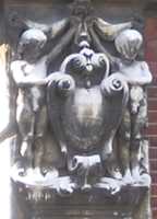  |
Central Foundation Girls School. |
|
College Road. The stone carvings on this side of the building were clearly not designed for a girl's school. The naked figures of children are clearly male. And the crest over the empty alcove is surmounted with a knight's helmet and the chevron has a couple of battle axes upon it. "Battle axe" is not a very complimentary way to describe a female. The girls school took over buildings originally designed for the Cooper's Company Boy's School. The three round hoops on the crest are the metal bands, which the coopers used for barrel-making, and in fact these axes were not used for war, but for cutting and shaping the wood for the barrels. (See No. 3. on Map) |
||
 |
Clock Tower. |
|
Outside Queen Mary College, Mile End Road. E1. Bird flying off into the sunset, with the inscription "Time Trieth Troth". The clock tower was erected in memory of Baron Hermann de Stern (1815 - 1887), a banker. The clock was to show the time for those passing along the Mile End Road near the People's Palace. (See No. 4. on Map ) Artist (?). Date (?) |
||
 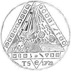 |
Cycle Track Milemarker & Secret Code. | |
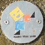 Mile End Park, Southern section. One of a thousand mile markers put up beside cycle tracks in the National Cycle Network to mark the millennium in 2000. This marker indicates that Victoria Park is a mile to the north and that Greenwich is 4 miles to the south. On the marker is a small black metallic medallion, which has on it a strange design with weird symbols written in the triangular border surrounding it. Within the triangle there are references to Isaac Newton's scientific discoveries. One can see a falling apple, his prism producing a spectrum, Newton's Cradle and a telescope. The feather is possibly a quill pen dipped in a skull-shaped inkwell. 2000 was also declared by the government to be Maths Year and if you look round this part of Mile End Park you will find a number of small wooden posts with an illustration of Pythagoras' theorem of right-angled triangles and labelled Maths Year 2000. This explains the Newton connection, but can anyone explain the significance of the coded message? If so, please email the webmaster. (See No. 5. on Map ) |
||
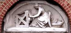 |
Draper's Hall Sculptures. | |
Campus of Queen Mary College. One of a group of statues which once decorated the hall of the Draper's Company and illustrate some of the stages of cloth making. The Drapers Company was largely responsible for funding the schools which were established on this site, which developed into the East London Technical College and finally Queen Mary & Westfield College. (See No. 6. on Map ) |
||
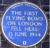 |
The First Flying Bomb. | |
Blue plaque on the railway bridge in Grove Road. In desperation at the end of the war, the Nazis directed a series of unmanned flying bombs towards London. Because their path could not be accurately predicted these were indiscriminate bombing of the civilian population. The Germans called them V1s while Londoners called them Doodlebugs. These were terror weapons. Once the engine cut out, the doodlebugs stalled and crashed to earth, exploding on impact. The web master can vouch for the fact that the buzz of the engine could be clearly heard even in the air raid shelters, and the long pause between it stopping and the final explosion was always a frightening experience. They were also called buzzbombs. (See No. 7. on Map ) |
||
 |
Firewatchers' Memorial | |
Next to the Grand Union Canal and between Tramway Court and Coalstore Court. This remembers those volunteers who at considerable risk to themselves stood outside during air raids to note and report where incendiary bombs were falling and helped to extinguish the fires. On this memorial it is written: In Memory of the Firewatchers who saved the gasholders in the early days of the Blitz.At the time when the photo was taken in 2008, the work was being repaired and the grey letters were missing. (See No. 8. on Map ) |
||
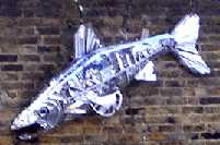 |
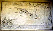
"Fish." | |
By the side of the Regents Canal, close to the Bridge where Ben Jonson Road crosses over it. However, it can not be seen from the bridge, so one has to view it from the towpath behind the Ragged School Museum. This sculpture has been made from scrap metal and includes a hub cap, and yet shows a beautiful shiny silvery fish. (See No. 9. on Map ) |
||
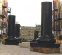 |
The Gas Works | |
Between Horseley Court and Mercer Court. These four truncated pillars originally held up a large cylindrical gasholder, which stood on this site. Part of the circular base has been marked out in the stonework. This site is therefore linked with the Firewatchers Memorial, for these were the gasholders which they saved. (See No. 10. on Map) |
||
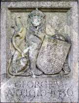 |
George V Gardens. | |
Tredegar Square. This commemorates the life of the king. On either side of the entrance is the royal crest with one of its supporters. Beneath is written King George V 1910-1936, which was the period of his reign. In 1935 the King celebrated his silver jubilee and a portrait sculpture showing his head can be seen in Jubilee Gardens on the Isle of Dogs. (See No. 11. on Map) |
||
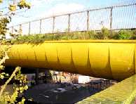 |
The Green Bridge. | |
Over Mile End Road near to the junction with Burdett Road. The vegetation is growing on the bridge not under it. The bridge links the two parts of Mile End Park on either side of the road. The idea was to give the impression of still walking in a Park while crossing a main road. Sadly, some of the original trees died from lack of water during the summer. (See No. 12. on Map ) |
||
 |
Guild of Handicraft. | |
401 Mile End Road, opposite Mile End underground station. The individualist building, which has BGVPHA written over the entrance, and is built on the site previously occupied by a large mansion called Essex House. In 1891 Charles Ashbee (1863-1942), who was influenced by William Morris and John Ruskin, moved in his Guild of Handicraft, which tried to put into practice the aims of the Arts and Crafts movement by preserving and practising many of the old hand skills of printing, bookbinding, furniture making and metalwork. After eleven years, the guild moved to Chipping Camden in Gloucestershire. (See No. 13. on Map ) |
||
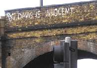 |
Innocence of George Davis | |
Graffito on the railway bridge over St Pauls Way. In 1975 George Davis was sentenced to 20 years imprisonment for robbery. His family and friends organised a campaign to have him released. Besides daubing slogans on walls and bridges, they shocked the English establishment when they perpetrated the most outrageous "crime" in British sporting history by digging up the test wicket at Headingley. The Home Secretary had to review the case, and freed Davis on the grounds that the police evidence of identification was open to doubt. However, in 1978 after being arrested again, he pleaded guilty of robbing a bank and in 1985 he was found guilty of trying to steal mailbags. This only goes to show that one should not believe everything one reads either on walls or in newspapers. (See No. 14. on Map ) |
||
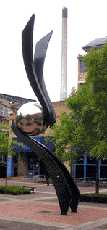 |
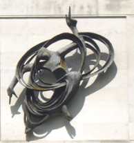
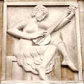
"Knowledge." | |
Library Square on the campus of Queen Mary & Westfield College. This statue symbolizes knowledge and the artist explains it by saying that the shiny globe symbolizes the world and its smooth surface shows the ease with which knowledge can be shared and spread. The globe is supported by two arms signifying that the giving and acceptance of knowledge upholds the world and its future. (See No. 15. on Map) Sculptress: Wendy Taylor, 2003. (See also Docklands Enterprise, Rope Circle, Timepiece and Voyage 2001 by the same artist.) |
||
 |
Landmarks |
|
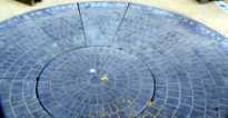
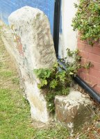
These two stones can be seen by the side of the towpath beside the Regents Canal (Grand Union Canal) almost under the railway bridge. They mark the border between the boroughs of Hackney and Tower Hamlets, These stones date from before 1880 as they are shown on a map of that date. The taller stone has the remains of an inscription which was at least six lines of writing, but now is too weatherworn to be readable. Many border stones had as little as two letters on them. (See No. 16. on Map) | ||
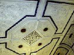 |
Local History Library Ceiling. | |
Bancroft Road, E1. This highly decorative moulded ceiling dating from 1862 is in the room on the first floor. Constructed originally for use as the Vestry Hall (the predecessor of the Town Hall) and as a meeting place for the Board of Guardians, the ceiling is so ornate because this was the Board Room. It became a library in 1901. (See No. 17. on Map) Architect: James Knight, 1862. |
||
  |
The New Globe. | |
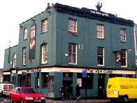
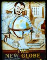
 Public House in Mile End Road next to the bridge over the Regent's Canal. It is called The 'New' Globe, but as it was built in 1821, so it is not far off being 200 years old. On the front is a dull modern sign. But an older and more interesting one (shown here) hangs beside the canal towpath to encourage passing canal boat crews to stop off here. Behind the pub, in what is now Mile End Park, there used to be the New Globe Pleasure Gardens. In 1844 a man announced that he would make an ascent in a balloon from here. He apparently chickened out and, without the crowd's knowledge, sent up a dummy made of a sack of straw wearing a hat and wig. The pilotless balloon eventually landed on farmland, where a farmhand ran to inform the farmer, saying: "Bring your gun. There is a monster in the long mead rolling about in agony of death. And there is an ordinary man laying dead in the grass". (See No. 18. on Map )
TO SEE THE BALLOON GO UP ~ HOLD MOUSE OVER GREEN BUSH. |
||
 |
Pointing Figure. | |
This sculpture is high up on the Physics building, but can be seen from the pavement in Mile End Road. The sculpture seems to be combining art and science. The figure is teaching from a book and is clearly involved in scientific circles. With its hands pointing downward and upward, the figure's thoughts seem to encompass both the earth and the heavens. (See No. 19. on Map) Sculptor: T. Huxley-Jones. Date: 1960. |
||
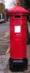 |
Post Box. | |
On the corner of Morgan Street and College Terrace. This ornate post box, still in excellent condition, is more than a century old as it has the monogram VR (for Queen Victoria) on the front. For the origin of the name Morgan Street see Lord Tredegar The Post Box is about 200 yards inside the circular limit round London of the two-penny post, which existed before the introduction of the Rowland Hill's universal penny post in 1840. (See No. 20. on Map ) |
||
 |
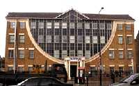
Queen Mary College. |
|
Six sculptures on the front wall of the building in Mile End Road. This was previously The People's Palace and was used for dramatic and other entertainment of the local population. The sculptures show Drama, Music, Dance, Brotherhood and Sport. The original People's Palace burnt down in 1931, and this building was re-opened by King George VI and Queen Elizabeth in 1937. It was one the first engagements he undertook as King, because his brother Edward VIII had originally promised to perform the opening, but was unable to do so because of his abdication. These carvings were specially commissioned for the new building. (See No. 21. on Map) Sculptor: Eric Gill. 1936. |
||
 |
The Ragged School Museum. | |
46-48 Copperfield Road. Dr Thomas Barnardo opened his first free school for poor children in Hope Place, Limehouse in 1868. The school moved here in 1872. The buildings had previously been warehouses storing lime juice, which was loaded from barges on the canal at the rear. Some of the original hoists used for loading and unloading can still be seen on the exterior of the building as can the school bell. At its peak it had 1,075 pupils, but closed in 1908. (See also on the Edinburgh Castle.) It is now a museum with some of the classrooms restored. It also houses an exhibition of the history of Tower Hamlets. Admission is free, but a donation would be welcome. Dr Barnado's later became a well known charity catering for poor and homeless children throughout Britain and the Commonwealth, but it started in London's East End. Open Wednesdays and Thursdays 10.0 am to 5.0 pm and the first Sunday in the month from 2.0 to 5.0 pm. (See No. 22. on Map ) |
||
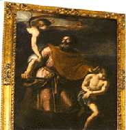 |
"Sacrifice of Isaac." | |
One of three artworks on display Bancroft Road Library, ground floor: 1. Large oil painting illustrating of the biblical story in Genesis chapter 22. In this story, Abraham is instructed by God to sacrifice his son Isaac as a test of obedience, but in the nick of time an angel is sent to prevent him doing so. Attributed to Claude Vignon 1593-1670. (See No. 23. on Map) 2. A triptych entitled "Thames Sunday Afternoon." Artist: Gerd Winner, 1972. 3. A collage style painting "Swanfield Street, Shoreditch." Artist: Isis Nassar. |
||
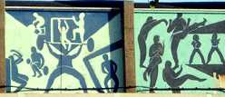 |
Mile End Park Stadium. | |
The southern part of Mile End Park. The illustration shows only a small section this mural, which illustrates a wide range of sporting activities. One of the buildings pulled down in order to build the stadium had been the Edinburgh Castle, a pub with crenulated parapet round the roof. In 1888, Dr Barnado took over the building and opened it as a Working Men's Club and a Peoples Mission Hall. On one occasion, he fed about 2000 homeless children here and on another day provided hot dinners for 1,200 poor adults. (See No. 24. on Map ) |
||
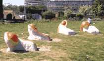 |
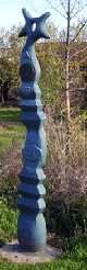
Sculptural Seating Installation. | |
The northern part of Mile End Park, in the Artspark. These four sculptures form a group, and each one seems to have as its focal point either an orange or a grapefruit. Designed to bring some brightness and fun into the park and also to provide seats. Described as temporary they are on in view in 2007, but may not be there for much longer. (See No. 25. on Map ) Artist: Leona Matusczak. |
||
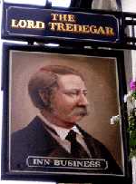 |
Lord Tredegar. | |
Portrait of Lord Tredegar on an inn sign in Lichfield Road. Lord Tredegar, formerly Sir Charles Morgan of Tredegar, owned an area of land in the area. Between 1820 and 1832 buildings of a superior class were erected around what is now Tredegar Square. They still stand out from much of the surrounding housing. Lord Tredegar has a pub, a square and a street named after him, for there is also a Morgan Street nearby. (See No. 26. on Map ) |
||
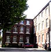 |
The Workhouse. |
|
Alderney Building, Mile End Hospital, Bancroft Road. This building was part of the workhouse when it was rebuilt in 1858. Following the introduction of the Poor Law of 1834, workhouses were used to house the poor. In these, families were split up by separating men from women and all were forced to do monotonous labour like breaking flints with a hammer or picking oakum � tasks also allocated to criminals in prison sentenced to hard labour. For this, the poor lived in squalid conditions and were supplied with the minimum of food. At that time poor people were regarded as lazy and needed to be taught to work. However, people soon regarded workhouses as intolerable and degrading and only resorted to them as the very last resort when completely desperate. They thought it preferable to sleep rough in the open and to beg or steal for food. Workhouses were abolished in 1929. Compare these conditions with that of the Board room of the Board of Guardians who ran this workhouse. (See No. 27. on Map) |
||
|| Beckton || Bethnal Green || Blackwall || Bow || Bromley-by-Bow || Canary Wharf || Canning Town || Chingford || Cubit Town || Custom House || East Ham || East India Dock || Forest Gate || Higham's Park || Leyton || Leytonstone || Limehouse || Little Ilford || Manor Park || Millwall || North Woolwich || Plaistow || Plashet || Poplar || St George's || St Katharine Dock || Shadwell || Shoreditch || Silvertown || Snaresbrook || Spitalfields || Stepney || Stratford || Upton || Walthamstow East || Walthamstow Village || Walthamstow West || Wanstead || Wapping || West India Dock || Whitechapel || Woodford || |
