St. GEORGE'S.
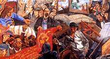 |
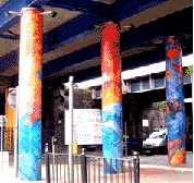
"Battle of Cable Street" Mural. |
|
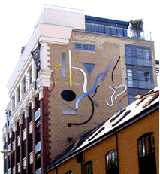
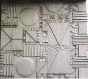
The illustration shows a detail from the large mural covering the whole side of the Library in Cable Street E1, which can be viewed from Library Passage. This commemorates the events of October 4th 1936, when Sir Oswald Moseley planned to lead a march of the black-shirted members of the British Movement of Fascists through the streets of East London and to hold street meetings in five boroughs, as a provocative show of strength. The local population who were predominantly Jewish or politically left-wing or perhaps both, strongly opposed the march. The five local mayors went and appealed beforehand to the Home Secretary, Sir John Simon, to ban the march; but were only able to speak to the deputy under secretary. Some Jews presented a hastily prepared petition signed by nearly 100,000 people; but the Home Office refused to act. By 1936, the Hitler had been in control of Germany for three years, had remilitarised the Rhineland and introduced anti-Semitic laws, Mussolini had invaded Abyssinia, Franco had started a civil war in Spain. and British Fascists had been escalating anti-Semitic attacks in the East End. So, the East End was more concerned about the threat of Fascism than was the British government at that time. The Fascists gathered near the Tower and the police tried to force a way through the massed crowd blocking the streets, to allow the march to proceed. This struggle became known as the Battle of Cable Street. Despite a number of arrests, the proposed march had to be abandoned. One result of the episode was that shortly after this, parliament passed a law banning political parties from wearing uniforms. (See No. 1. on Map) Artist: David Binnington. 1983. |
||
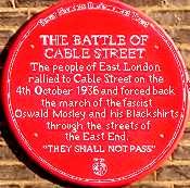 |
Battle of Cable Street Plaque. |
|
A red wall plaque commemorating the Battle of Cable Street can be found at 3-5 Dock Street. It was decided that a blue plaque would not be Politically Correct. See the entry above for the background. The battle was between the local inhabitants and the police who were trying to clear a path for the Fascists. The scale of the battle can be judged by the fact there were 6000 police on foot as well as all the mounted police in London. The tactics included building barricades across streets, persuading a driver to stop his tram at the top of Commercial Road so as to block that street and the throwing of marbles on the ground in front of the police horses to destabilise them and prevent them charging the crowds defending their right to live in peace without Fascist racist intimidation. Cable Street was not the intended battle scene. Moseley planned to march down Commercial Road, but when the police found it blocked, they tried to outflank the protesters by going down Cable Street, and it was here that much of the violence took place. (See No. 2. on Map) |
||
 |
Bernhard Baron Settlement. |
|
Henriques Street. From 1930 to 1973, this was the largest Jewish Settlement in the East End. Founded by Basil and Rose Henriques, this settlement catered for all ages. It provided an ante-natal clinic, creche, toddlers play centre, youth clubs and social activities for middle-aged and elderly. It also provided free medical help and legal advice. The building housed a Liberal-Reform Synagogue. There are two commemorative inscriptions beside the front entrance. The high partly-latticed parapet round the flat roof is still visible. It was there that youngsters used to play ball games, box, learn ballet-dancing and do PE. Basil Henriques later received a knighthood for his work as a juvenile magistrate, and after his death the street was named after him. Bernhard Baron was a Russian born American Jew who made his fortune by manufacturing Carreras cigarettes. Besides financing this settlement he donated large sums to hospitals and children's homes. (See No. 3. on Map) For further information on this Settlement see Oxford & St Georges Clubs. and History of The Settlement Synagogue |
||
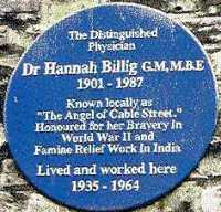 |
Dr Hannah Billig. |
|
198 Cable Street has a plaque stating that this was the home and surgery of Dr Hannah Billig. Dr Billig was awarded the George Medal for bravery and devotion to duty. She tended casualties in the Blitz often entering unsafe damaged buildings to do so. On one occasion she did so despite being wounded herself. She was also awarded the MBE for work she did during a famine in Bengal. Locally she was known as "The Angel of Cable Street". Recently a new block of housing was erected nearby and was called Angel Court in her honour. (See No. 4. on Map) |
||
 |
Boyd Street Mural Sculpture. |
|
On the back wall of 9 Boyd Street. This sculpture has a musical theme as does the back gate of the building in Fairclough Street. The sculpture is best viewed from Henriques Street. (See No. 5. on Map) |
||
 |
"Co-operation" |
|
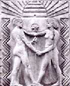
Carving over the doorway of No, 1 Prescot Street, E1. This building was originally designed to house the offices of the CWS, the Co-operative Wholesale Society. The object of the Co-op was to purchase goods at wholesale prices and to pass this benefit on to their members as lower retail prices and in dividends, rather than in other retail outlets where it went to provide dividends to investors. The design symbolises this by showing two individuals shaking hands beneath a hive of bees where the bees gain benefits from mutual co-operation. Since 1999, the building has contained apartments. (See No. 6. on Map) Sculptor: J.C. Blair. 1930-33. |
||
 |
The Old Dispensary. |
|
Leman Street. Now a public house, the building was erected 1858 to house the Eastern Dispensary. This had been started by a group of doctors in 1782 and was one of the first attempts to provide medical treatment to the poor of the area. (For another early attempt see Royal London Hospital) Inscriptions still on the building show that it relied on voluntary contributions from charitably minded people. Behind the Dispensary is a German Lutheran Church and School. The Germans came to the East End originally around 1700 as sugar refiners, a smelly trade which had to be carried on outside the city walls. (See No. 7. on Map) |
||
 |
"Face Railings" |
|
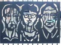
On the corner of Royal Mint Street and Mansell Street. These railings around a car park have been decorated with a series of different cast iron portraits of local people. The project is part of the One Mile East Public Art Trail. (See No. 8. on Map) Sculptor: Hillary Cartmel based on the artwork of Stephen Johnson, Sonia Martin, Michelle Rowland & Julie Sassoon. Begun 1999. |
||
 |
Gunmakers' Company Proof House. | |
46-50 Commercial Road. The Gunmakers are one of the ancient city livery companies, but they were banished from the city because of the hazardous nature of their work. They prove guns by testing them out. The wisdom of the expulsion was shown some years later, in 1757, when the building had to be rebuilt because of the damage caused to its structure by various explosions. Some windows have been bricked up. This is in not because of the old window tax, but to lessen the noise being heard outside. The building is well sited because the East End has been used for the making and firing of guns for at least five centuries. (See also Cnihtengild. For the Proof House see No. 9. on Map) |
||
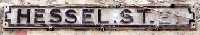 |
Hessel Street. | |
Noted for its market. In early part of the twentieth century it was predominantly Jewish. The street is named after Phoebe Hessel (1713 - 1821), who was born in Stepney but, masquerading as a man, she joined the army. She served as a private in the 5th Regiment of Foot and was wounded in the arm, while fighting the French at the Battle of Fontenoy in 1745. She first married private Samuel Golding and later wed Thomas Hessel. As an ex-soldier she was given a military pension. She lived to be 108 and was buried in a churchyard in Brighton. (See No. 10. on Map) |
||
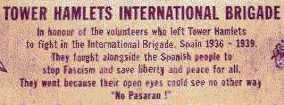 |
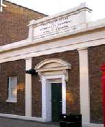
International Brigade Memorial. | |
On the front of the Public Library (previously St George's Town Hall) in Cable Street. During the Spanish Civil War in the 1930s when Hitler and Mussolini supported Fascist General Franco in his campaign against the democratic forces. Little support was given to the anti-fascists by governments, but individuals volunteered to go out and fight. This plaque commemorates those who fought and died in that International Brigade. Their courage inspired Ernest Hemingway to write For Whom The Bell Tolls. The suffering caused by the Fascists using Nazi aircraft to bomb villages inspired Picasso to paint Guernica. (See No. 11. on Map) |
||
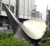 |
"Judex" |
|
Metal sculpture in Goodmans Square, E1. This sculpture shows a fluidity of line. (See No. 12. on Map) Artist: Keith McCarter Date: 1983. |
||
 |
Leman Street Bridge. |
|
Decorated columns of the bridge, carrying the Docklands Light Railway over the end of Leman Street. This is part of the One Mile East Art Trail, and was produced under Look Ahead's Urban Regeneration Project. (See No. 13. on Map) Designer: (?) date (?) |
||
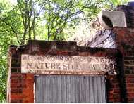 |
Nature Study Museum. | |
In the Churchyard of St Georges-in-the-East. There are two buildings which are almost completely roofless. Over the door of one is written: Metropolitan Borough of Stepney NATURE STUDY MUSEUM. The buildings date from c. 1877, when they served as a mortuary. However, in 1904 the Rector converted them into a museum in an attempt to teach city slum dwellers something about nature, because the local children saw so little greenery around them. During the Summer, this museum often received 1000 visitors per day. Most of these were local school children. The live exhibits included reptiles, amphibians and tropical fish in tanks. There were also stuffed animals and arrays of butterflies etc. The museum shut in 1939 when the children were evacuated out of London. It now appears that Nature has fully taken over its own museum. (See No. 14. on Map) |
||
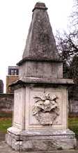 |
Raine Family Tomb. |
|
In the Churchyard of St Georges-in-the-East just off the Highway. This large monument can be clearly seen directly to the east of the Church. Henry Raine (1679 - 1738) was a Brewer in Wapping who used his wealth to endow a charity school in Raine Street, Wapping in 1719. The school has moved several times and is now in Bethnal Green, still under the auspices of the Raine Foundation. The buildings in Raine Street and Cannon Street Road are also still standing, but have been adapted and used for other purposes. On 121-123 Cannon Street Road the name can still be clearly seen. Incidentally, it was in a room of No. 125, which belonged to the school, that Basil Henriques started his first Jewish youth club. (See No. 15. on Map) |
||
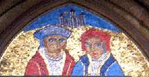 |
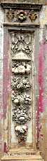
Roman Catholic Church of English Martyrs. |
|
One of a pair of Mosaics with some gold tessera which are over the main doorway of the Roman Catholic Church of English Martyrs, Prescot Street near Tower Hill. The church was built in 1875 by the Pugin brothers and was intended for the use of the many Irish workers in the nearby docks. The martyrdoms occurred in the reigns of Henry VIII and his son Edward VI. The figure on the left is Sir Thomas More. and on the right is John Fisher, Bishop of Winchester. They were each beheaded by Henry VIII in 1535 because they did not accept him as the head of the Church of England. These two are also linked because they share the same saint's day in the Christian calendar. (See No. 16. on Map) Architects: Pugin Brothers. Mosaics: Arthur Fleichmann. 1875. |
||
 |
Mary Sambrook Mural. |
|
Part of a mural on the wall of the play area of the Mary Sambrook Childrens Centre, 125 the Highway. This mural was painted by students of Queen Mary College and was completed in 2005. (See No. 17. on Map) |
||
 |
Skyline Plaza Building. |
|
62-82 Commercial Road, on the corner with Back Church Lane. The lower side wall of the building shows a modern sculptural design. There are other designs of a similar style on the Henriques Street side of the building. Commercial Road derived its name from it being the road along which much of the goods to and from the East India and West India Docks used to travel. (See No. 18. on Map) |
||
 |
Swedish Monument. |
|
In the gardens in Wellclose Square, near Swedenborg Gardens. This incised metal plate fixed to a small stone monument commemorates the first Swedish Church in London (1728-1911) and was set up to celebrate the 250th anniversary of the church's founding. Emanuel Swedenborg was a Swedish author and mystic, who lived in Wellclose Square for the last four years of his life. He died in 1772, and was buried in the Swedish church. There were also Norwegian and a Danish churches in the East End, which were established because of the large Scandinavian timber trade through the docks. The Scandinavians were so numerous in the East End that they established a Danish-Norwegian embassy in Wellclose Square. (See No. 19. on Map) Designer: Mrs T Lyth. Date: 1960. |
||
 |
Theatre Bollards. |
|
In front of 18 Ensign street. There are a number of identical bollards with the monogram RBT with a crown over the top. This stands for the Royal Brunswick Theatre, which was built in 1828 to replace the Royal Theatre. But the Brunswick did not last long, as the building collapsed almost as soon as it was opened. Today, it may seem a strange place to build a theatre, but the area had a theatrical past. In 1731 a theatre opened up in Leman Street, where David Garrick played for many years. A few years later, following the production of an anti-government play, parliament shut down all unlicensed theatres. However, a way was soon found to circumvent the law. The Goodman's Field Theatre opened up as a music hall and sold tickets for a short musical performance, and the audience were then welcome to stay and see the play, free of charge. Nearby, there still remains Wilton's Music Hall. (See No. 20. on Map) |
||
 |
Wilton's Music Hall. |
|
Graces Alley, E1. Two decorative designs placed on either side of a doorway. Behind this door there used to be the Prince of Denmark Tavern, known for it's mahogany bar. The owner of this pub, John Wilton, built a big music hall behind it to attract customers. This is the oldest example of a large music hall still surviving in the country. It opened in 1858 and is of a surprising size as it could squeeze in 1,800 people if really necessary. It has a balcony supported by barley sugar shaped columns. The Music Hall continued for 30 years. In later life it was used as the Methodist Mission in the East End and later still as a store room for rags. At one time it was in danger of being pulled down, but a popular campaign prevented this. Various attempts have been made to restore the building and it featured as one of the buildings on the television programme "Restoration". (See No. 21. on Map) Date: 1858. |
||

OTHER AREAS COVERED:-
|| Beckton || Bethnal Green || Blackwall || Bow || Bromley-by-Bow || Canary Wharf || Canning Town || Chingford || Cubit Town || Custom House || East Ham || East India Dock || Forest Gate || Higham's Park || Leyton || Leytonstone || Limehouse || Little Ilford || Manor Park || Mile End || Millwall || North Woolwich || Plaistow || Plashet || Poplar || St Katharine Dock || Shadwell || Shoreditch || Silvertown || Snaresbrook || Spitalfields || Stepney || Stratford || Upton || Walthamstow East || Walthamstow Village || Walthamstow West || Wanstead || Wapping || West India Dock || Whitechapel || Woodford || |