LIMEHOUSE.
PUT MOUSE OVER  TO READ NAME ~ CLICK FOR PHOTO & EXPLANATION.
CONTENTS |
||
| 1. Anchor | 2. Clement Attlee | 3. Cattle Trough |
| 4. Chun Yee Society School | 5. Dragon's Gate | 6. Funeral Parlour |
| 7. Gas Street Lamps | 8. The Grapes | 9. "Herring Gull" |
| 10. Limehouse Accumulator Tower | 11. The Mosaic | 12. Narrow Street |
| 13. Our Lady Immaculate | 14. Pyramid Tomb | 15. "Restless Dream" |
| 16. Sail Maker | 17. Sailors Palace | 18. St Anne's Church |
| 19. St Dunstan's Wharf | 20. Royal Foundation of St Katharine | 21. First Salvation Army Hostel |
| 22. Stevenson's Railway Viaduct | 23. Steven Hawking School Gates | 24. War Memorial |
| 25. The White Swan | ||
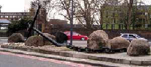 |
Anchor. |
|
At the Junction of Salmon Lane and Commercial Road. This has been landscaped on a traffic island outside what was previously the Empire Memorial Hostel for Seamen. It was a memorial to those merchant seamen who died in World War 1. (See No. 1. on Map) |
||
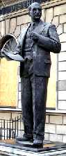 |
Clement Attlee. |
|
Outside the old Library Building 638 Commercial Road, next to Norway Place. Clement Attlee (1883-1967) was successively, Secretary of Toynbee Hall, Mayor of Stepney, MP, Leader of the Labour Party, Deputy Prime Minister (1942-45) and Prime Minister (1945-51). His government introduced many social reforms including the National Health Service. After retiring from Parliament he was given an earldom. (See No. 2. on Map) Sculptor: Frank Forster. 1988. |
||
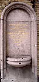 |
Cattle Trough. |
|
Underneath the railway bridge over Commercial Rd by the junction with Lowell Street. The inscription states:
The trough has gone but the fountain remains (but is not working). It is interesting that it was called a "Cattle" trough and not a horse trough. This implied that it was for the cattle then being herded down Commercial Road, probably to the slaughter houses in Whitechapel. (See No. 3. on Map) |
||
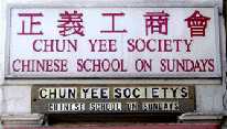 |
Chun Yee Society School. |
|
50 East India Dock Road, on the corner with Birchfield Street. The society runs a Chinese school and also a Chinese old peoples club. Apart from the Chinese restaurants, this is one of the few reminders of the many previous Chinese residents. During the post-war unemployment In 1919, the Chinese suffered from Xenophobia which gave rise to anti-Chinese rioting. They were unjustly accused of being behind the "white slave trade". The road opposite is called Canton Street with Pekin Street and Nankin Street running parallel to it. All three of these are crossed by Saracen Street, but this latter does not have the same historical or geographical significance. (See No. 4. on Map) |
||
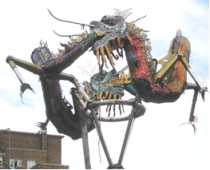 |
Dragon's Gate. |
|
Junction of Mandarin Street and East India Dock Road. In the 18th century Limehouse was London's Chinatown. There was a population of Chinese sailors who had come off the boats. The whole area round the London docks was a crime area. Readers of the Sherlock Holmes stories will know that Limehouse was thought to be filled with Chinese opium dens. However, criminality amongst the Chinese was probably far less than that of their English neighbours. The main reason for building St Katharine Dock and the other enclosed docks was to cut the heavy losses from thefts by workers unloading ships in mid Thames, as had been the earlier practice. The past Chinese presence is commemorated by the name Mandarin Street and by this attractive sculpture. (See No. 5. on Map) Artist: Peter Dunn. Date 1997. |
||
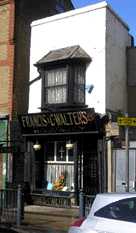 |
Funeral Parlour. | |
Francis & Walters Funeral Parlour, 811 Commercial Road. This is at least 200 years old and English Heritage has assisted in its preservation. The East End has a tradition of having elaborate funerals. Many people start saving up for their funeral at an early age. They seem to work on the principle that "you may not be able to take it with you; but you can at least go out in style." (See No. 6. on Map) | ||
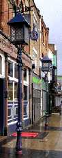 |
Gas Street Lamps. | |
Outside the Star of the East public house in Commercial Road. There are two surviving gas street lamps. These had to be lit each evening by a man who went round with a light on the end of a long pole. (See No. 7. on Map) | ||
 |
The Grapes. |
|
76 Narrow Street, Limehouse. An old pub claiming to go back to 1583. This may be a little exaggerated as the adjoining houses in the row are from the seventeenth or early 18th centuries. Some think that this is the pub that Charles Dickens had in mind when he described it in Our Mutual Friend but called it The Six Jolly Fellowship Porters. (See also Narrow Street) (See No. 8. on Map) | ||
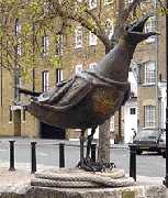 |
"Herring Gull." |
|
Ropemakers' Fields off Narrow Street, Limehouse. Some seagulls seem large, but this 2-metre high statue seems to be a holiday-maker's nightmare. Ropemakers' Fields and Cable Street have names derived from the trades carried on there. The Docks together with the shipbuilding yards in the area needed many ancillary trades. Many ropes were required for one sailing ship. (See No. 9. on Map) Sculptress: Jane Ackroyd. 1994. |
||
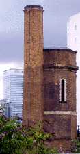 |
Limehouse Accumulator Tower. |
|
Mill Place off Commercial Road. This octagonal tower was built in 1869 was used to store water which provided the hydraulic power for the cranes and locks in the nearby Limehouse basin. The water was stored in a cylinder capped by heavy weight. Water was pumped into the cylinder raising the 80 ton weight containing gravel, which put the water under a pressure of about 700 pounds per square inch. (See also London Hydraulic Company.) The tower is occasionally open for visits. Contact British Waterways London for details. (See No. 10. on Map) |
||
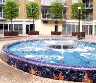 |
The Mosaic. |
|
In the centre of a courtyard which lies between the end of Branch Road and Narrow Street. Fountain with brightly coloured mosaic surround. There are two mosaic covered seats, one of which can just be seen behind the fountain in the illustration. (See No. 11. on Map) |
||
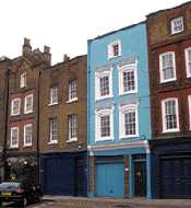 |
Narrow Street. |
|
Row of houses, numbers 78 - 94. This picturesque row of houses dates back to before the middle of the eighteenth century. Both Turner and Whistler came here to paint. (See No. 12. on Map) |
||
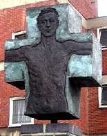 |
Our Lady Immaculate Catholic Church. |
|
636 Commercial Road, Limehouse, near the junction with Island Row. This sculpture is outside the front of the church, and breaks with the stereotyped statues of the crucifixion. (See No. 13. on Map) |
||
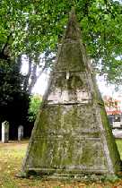 |
Pyramid Tomb. |
|
In the churchyard of St Anne's, to the west of the Church. This unusual monument is almost three metres high. It is inscribed in Hebrew and English "The Wisdom of Solomon". In the Bible, Solomon is described as being wise, but the phrase "Wisdom of Solomon" is used as a title in the Apocrypha and is not in the Hebrew Bible. (See No. 14. on Map) |
||
 |
"Restless Dream." |
|
Over the Western entrance to the Limehouse Link Tunnel. This is a large sculpture which covers most of the wall over the tunnel. (See No. 15. on Map) Sculptor: Zadok Ben-David. Date 1993. |
||
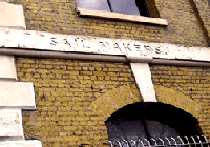 |
Sail Maker. |
|
11 West India Dock Road. This building was once housed a sail maker and ship chandler, but now lies derelict and unoccupied. Built in 1860, when steam was already being introduced, with hindsight we can see that it would not last very long. The trades were deeply engraved in stonework and still survive. One also can just make out that this was part of India Terrace. (See No. 16. on Map) |
||
 |
Sailor's Palace. | |
At the end of Commercial Road where it meets West India Dock Road. This building was erected in 1901 as the headquarters and hostel for the British and Foreign Sailors Society. Decorated in the Arts and Crafts style, it is lavishly decorated with nautical symbols such as Britannia as a ship's figurehead with a ship under each arm. There are numerous inscriptions. One lists the six continents (including Oceana) which sailors visited, and another the four winds that blew on them there. There is one inscription naming the building as the Passmore Edwards Sailor's Palace. John Passmore Edwards (1823 � 1911) was a philanthropist who donated money for the free libraries, museums, art galleries and also for colleges and hospitals, many of these buildings can be seen in East London. He was a self-made man, who after being sacked from his first job, became in turn a journalist, MP and editor of the Echo, the first half-penny newspaper. For another example of his generosity see Whitechapel Art Gallery ( For the Palace, see No. 17. on Map) |
||
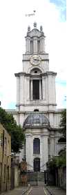 |
St Anne's Church. |
|
The main entrance is in Newall Street, but it is adjacent to East India Dock Road. St Anne's is one of the three great Hawkesmoor churches in the East End. Begun in 1714, it was eventually consecrated in 1730. In the churchyard there are two particularly interesting memorials: The Pyramid and the War Memorial. (See No. 18. on Map) |
||
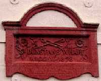 |
St Dunstan's Wharf. |
|
No. 142 Narrow Street, Limehouse. This plaque dated 1878 is part of the frontage of the original buildibg which has been preserved, while rear has been redeveloped. This reminds us that shipbuilding and repairing took place along this stretch of the river as does the Sailmaker's House at No. 136. Both buildings still have their cranes still fixed on the front. Note the implements used by ship builders on the plaque and that the same tongs are also associated with St Dunstan and can be seen on St Dunstan's Church, Stepney, where the story is explained. (See No. 19. on Map) |
||
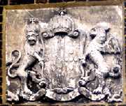 |
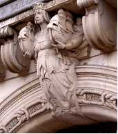
Royal Foundation of St Katharine. |
|
Butcher Row. The Royal Foundation of St Katharine was founded in 1147 by Queen Matilda and then re-founded by Queen Eleanor in the 13th century, when it was situated by the Tower of London. It was one of the main religious hospitals like St Batholemew's (Barts) until it was pulled down to make way for St Katharine Dock in the 1825. It was removed first to Regents Park area, then to Bromley Hall and finally came here after World War II. Many of its earlier historic monuments have accompanied them in their wanderings and today are housed in the chapel and cloisters behind the Master's House. The latter was built in 1794 0n the cellars of a previous house destroyed in The Radcliff Fire. The Foundation has received royal patronage since its first foundation and the coat of arms illustrated is on the front of the building. [If anyone knows the name of the bearer of these arms, please contact the web master. ] (See No. 20. on Map) |
||
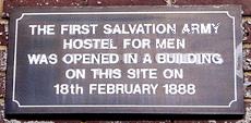 |
First Salvation Army Hostel. |
|
21 West India Dock Road. Opened February 1888, this hostel had 150 beds which were used to give shelter to the homeless poor. The original building has been replaced and the site is now occupied by the offices of British Telecom. This plaque is all that remains to reminds us of the past. See also William Booth, the founder of the Salvation Army. (See No. 21. on Map) |
||
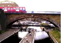 |
Stevenson's Railway Viaduct. |
|
One arch of the viaduct over the Regent's Canal, viewed from Commercial Road looking towards Limehouse Basin (formerly Regent's Canal Dock). This viaduct was built in 1839 by George and Robert Stevenson. At first the railway trains at 15 minute intervals were pulled by cables attached to fixed winders at the end of the three and the half mile track. It was a single track and was the first railway to be controlled by an electric telegraph. Locally, it was known as "the fourpenny rope". Later the London and Blackwall Railway used steam locomotives to transport goods and passengers to and from the docks. After more than 160 years the viaduct is still being used by the Docklands Light Railway. Regents Canal, which, opened in 1820, linked up with the Grand Union Canal at Paddington. It thus made a north circular canal round London for water transport in the same way that the North Circular Road later did for motor transport. Together with the Limehouse Cut, it enabled goods unloaded in the Limehouse Basin to be transported to places all over England. The canal was named after George IV who from 1811 to 1821 was Prince Regent during the illness of his father, George III. (See No. 22. on Map) |
||
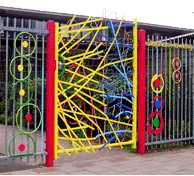 |
Steven Hawking School Gate. |
|
Brunton Place, off Commercial Road. If you go down Brunton Place you can hardly miss this unconventional and brightly coloured gate. They have also decorated some of the surrounding railings, and there are also some attractive mosaics displayed on the front walls of the building. (See No. 23. on Map) Designer: Helena Roden.. (See also "Anemonies" and "Old Ford Primary School Gates" by the same artist) |
||
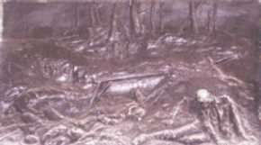 |
War Memorial |
|
In the churchyard of St Anne's Church, East India Dock Road. This bronze is on the base of the Limehouse War Memorial and is a realistic depiction of the carnage and destruction caused by the trench warfare in Flanders in World War 1. It is in marked contrast to the idealistic figures sometimes shown on other war memorials. (See No. 24. on Map) Sculptor: Arthur G Walker. C. 1920. |
||
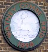 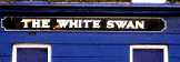 |
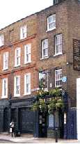
The White Swan. |
|
At the corner of Butcher Row and Commercial Road. During the 19th century, at the time of Irish potato famine, this area had a large Irish population. So many Irish patronised this pub that it was known locally as "Paddy's Goose". But that is not the only zoological misnomer. The top illustration shows the only pictorial sign on the pub which depicts a white deer. That oddity has to be blamed on the brewers, whose trademark it was, rather than upon the Irish. (See No. 25. on Map) |
||

OTHER AREAS COVERED:-
|| Beckton || Bethnal Green || Blackwall || Bow || Bromley-by-Bow || Canary Wharf || Canning Town || Chingford || Cubit Town || Custom House || East Ham || East India Dock || Forest Gate || Higham's Park || Leyton || Leytonstone || Little Ilford || Manor Park || Mile End || Millwall || North Woolwich || Plaistow || Plashet || Poplar || St George's || St Katharine Dock || Shadwell || Shoreditch || Silvertown || Snaresbrook || Spitalfields || Stepney || Stratford || Upton || Walthamstow East || Walthamstow Village || Walthamstow West || Wanstead || Wapping || West India Dock || Whitechapel || Woodford || |