ISLE OF DOGS. � Millwall, Cubitt Town.
| Millwall got its name from the wall that bordered the Thames attempting to minimize flood damage. In the 18th century there were at least seven windmills along this stretch. While on the other side of the Isle the wall was black giving rise to the name Blackwall. For the origin of Cubitt Town see Cubitt Arms. |
 TO READ NAME ~ CLICK FOR PHOTO & EXPLANATION.
CONTENTS |
||
| 1. Arnhem School Ceramics. | 2. Bell Gates. | 3. The Cubitt Arms. |
| 4. Cubitt Infant School Mural. | 5. The Deer of Millwall | 6. "Docklands Enterprise." |
| 7. George Green & the Dragon. | 8. Foot Tunnel. | 9. Gazebo. |
| 10. King George V. | 11. Great Eastern Slipway. | 12. International Hotel |
| 13. Kneeling Woman. | 14. "London River Man". | 15. Millwall Dock Cranes. |
| 16. Millwall Dock Lock Machinery. | 17. The Plate House. | 18. Rotating Sculptures. |
| 19. Schooner. | 20. J. Scott Russell. | 21. Self-Storage Artwork. |
| 22. The Space | 23. Technology or Art? | 24. Top Hat. |
| 25. Railway Viaduct. | 26. "Vowel of Earth Dreaming Its Root". | 27. "Wind of Change." |
| 28. Workers' Garden. | ||
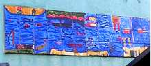 |
Arnhem School Ceramics. | |
On the side wall of E Klein & Co, 122 Westferry Road. An extensive array of specially designed ceramic tiles. The designs were made by the pupils of Arnhem Wharf Primary School and decorate one boundary wall of their playground. They are partially visible from the street outside. The tiles shown are just a small section of a larger design, which shows the river Thames flowing round the loop of the Isle of dogs. The blue, therefore, running across the centre of the tiles symbolises the water of the river. The road is so named because from at least the seventeenth century there used to be two ferries crossing the Thames from the Isle of Dogs , known as the East Ferry and the West Ferry. (See No. 1. on the MAP ) |
||
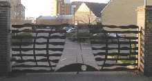 |
Bell Gates. | |
Old Bellgate Place, Westferry Road. This a gate to the entry of a housing complex. (See No. 2. on the MAP ) |
||
 |
Cubitt Arms. | |
The sign of a public house on the corner of Olliffe Street and Manchester Road. Cubitt Town got it's name from the head of Messrs Cubitt & Co. who were responsible for building much of the housing here. The purpose was to provide accommodation for their workers in the ship-building yards and docks. Sir William Cubitt (1785-1861), Lord Mayor of London. and as a civil engineer, built among other things, the Southeastern railway, docks in Cardiff and part of the Great Exhibition of 1851. (See No. 3. on the MAP ) |
||
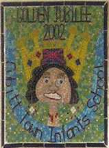 |
Cubitt Infant School Mural. | |
Manchester Road. Mosaic mural designed by pupils to mark the golden jubilee of their school in 2002. Visible from the road. (See No. 4. on the MAP ) |
||
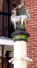 |
The Deer of Millwall. | |
St Hubert's House in Janet street. In each of the two courtyards there stands an octagonal pillar about seven foot tall with an antlered deer on top and entitled "Stags". On each pillar there are eight small pulley wheels as shown in the photo. Below, but not shown, are eight inverted hooks. They were used for washing lines in the green days before spin and tumble dryers. St Hubert (656-727) was a European courtier whose main pastime was hunting. He lived mostly in the Benelux area. It is said that on one occasion he came across a deer, which spoke and persuaded him to covert to Christianity. He was later made the patron saint of huntsmen, (if those who hunt animals for pleasure are thought worthy of having a patron saint.) (See No. 5. on the MAP ) Sculptor: Gilbert Bayes. Date: 1935. (See also Madonna and Child. by the same artist.) |
||
 | "Docklands Enterprise" | |
Rising out of West Dock and can be viewed from Marsh Lane. Sculpted with a chrome finish, this work seems to be based on the shape of the Isle of Dogs. It shows Docklands as having a bright and shiny exterior. (See No. 6. on the MAP ) Sculptress: Wendy Ann Taylor. Date: 1987. (See other works by same artist: "Knowledge" , "Rope Circle", "Timepiece" and "Voyage 2001") |
||
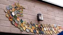 | George Green and the Dragon | |
George Green School, Manchester Road. The front of the building is decorated with designs of ceramic tiles. This fearsome dragon guards one of the entrances breathing fire on late-comers. George Green ( ? � 1849) was a successful shipbuilder who used his wealth to found a Seaman's Hostel, alms houses and this school. The school was originally in Poplar. (See No. 7. on the MAP ) |
||
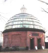 |
Foot Tunnel. | |
The entry to the tunnel is by the side of thee Thames in a little park in Saunders Ness Road. This is a tunnel for pedestrians to cross to Greenwich under the River Thames (no charge). This tunnel is 390 metres in length. There are 88 steps down from the Island Gardens end and 100 steps up at Greenwich, but there are also lifts. Island Gardens, the little park here, was laid out in 1895 by the Naval Hospital in Greenwich so as to improve their view across the river. Previously it was a scrap metal dump. From the north bank, there is a fine panoramic view of the Hospital, Royal Naval College, Maritime Museum and the surrounding buildings. (See No. 8. on the MAP ) Designer: Sir Allen Binnie. Date: 1902. |
||
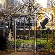 |
Gazebo | |
St John's Park, Cubitt Town. This is situated on Manchester Road and close to Plevna Street. It was designed to appeal to children and is decorated with birds and mushrooms. The word gazebo is pseudo Latin meaning "I will gaze" (or look out). (See No. 9. on the MAP ) Date: 1989. |
||
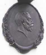  |
King George V | |
Jubilee Crescent, Cubitt Town, which contains nos. 327- 355 Manchester Road. The crescent got its name because it was built in the year of the Silver Jubilee of King George and Queen Mary. They are each depicted in bas relief on the front of one of the houses in the crescent. (See No. 10. on the MAP ) Architect: G R Unthank. Date: 1935. |
||
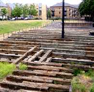 |
Great Eastern Slipway | |
At the end of Napier Avenue, beside the Thames Walkway. These massive timbers are thought to be the partial remains of the slipway from which Isambard Kingdom Brunel's "Great Eastern" was launched. The shipyard was owned by Scott Russell who cooperated on the design of the ship. This giant vessel had steam-driven paddle wheels and screw propeller as well as six masts with sails. (belt and braces !) In 1857, when it was completed it was about 700 feet (213 metres) long, and it was by far the largest ship in the world. It was to be 40 years before a larger one was built. The size made it difficult to launch and Brunel made 13 unsuccessful attempts before it was finally floated on the 14th attempt. Brunel feared that it might go down the slipway with such momentum that it would cross the Thames and crash into the opposite bank. (The Thames at this point is not more than 1000 feet wide). So he launched it sideways. Initially, the ship moved a few inches and then stuck. So they built this new slipway and used mechanical rams to push the ship to the water and finally it floated off on a high tide. Although innovative in its size, its two skinned metal hull and many other items, as a passenger carrying liner it was a financial disaster. After the delayed launch, Scott Russell went broke and Brunel also had financial problems. The ship was later employed to lay the first telegraph cable across the Atlantic, as it was the only one big enough for the job. (See No. 11. on the MAP )
|
||
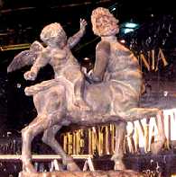 |
International Hotel. | |
One of two classical style statues outside the entrance of the International Hotel in Marsh Wall. This shows a child mounted on a centaur. The other shows a woman and winged child seated on a lioness. The name of the road is due to the fact that in the middle ages the Isle of Dogs was often referred to as Stepney Marsh. It was only with the engineering works required for constructing the docks at the beginning of the 19th century, that the area was properly drained. (See No. 12. on the MAP ) |
||
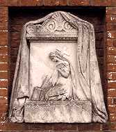 |
Kneeling Woman | |
Glenafric Avenue. Set in a brick wall by a play area. There are three other stones carved with inscriptions which seem to indicate that they come from a demolished church. One states that it was Laid by J Westwood Junr. Esq, July 21st 1862 and mentions Rev. Thomas Penrose, Superintendent Minister. It also says that it was relaid by Mrs F Thorne May 18th 1905. The wall it is now set in looks post 1945, so that it must have been moved again. (See No. 13. on the MAP ) |
||
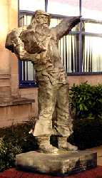 |
"London River Man." | |
Outside Ensign House, Marsh Wall, E14. Inscribed: "This sculpture salutes all London River Workers � Tosshers � Bargees � Dockers � Aletasters � Coalheavers � Ferrymen." (Tosshers or Toshers got their name from "Tosh", which was the word used for items that were found in the mud of the Thames and sold for whatever they could get for it.) . (See No. 14. on the MAP ) Sculptor: John W. Mills. Date: 1987 (?) |
||
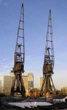 |
Millwall Dock Cranes | |
Two of the giant dock cranes which unloaded the cargoes in the busy dock. Millwall got it's name from the fact that along this stretch of the Thames embankment there used to be seven windmills. Millwall dock was opened in 1868, and ships came to it from all over the world. (See No. 15. on the MAP ) |
||
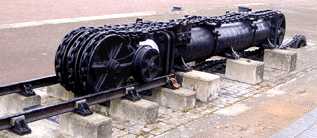 |
Millwall Dock Lock Machinery. | |
At the entrance to Millwall Docks there was a lock, allowing water level in the Dock to be different to that of the Thames. Some of the Lock equipment has been preserved. This shows the chain pulley system which gave mechanical advantage to tackle heavy weights. This was worked by hydraulic power. The water pressure forced the piston up the tube, moving the wheels up the railway track to the left of the picture. This set the pulleys moving which pulled the chain at the far right end, which in turn opened the lock gate. (See No. 16. on the MAP ) |
||
 | The Plate House. | |
In the middle of Burrells Wharf development. This large building known as the Plate House or Gantry House was central to the building of iron ships which was carried out here. It was here that the massive plates for the hulls were manufactured. They were moved about by overhead cranes on gantries. Hence the names for the building. The plates for the Great Eastern came from here. After Scott Russell went out of business, the site was taken over by Napier's, another well known firm, and this explains the name Napier Avenue. The building has been converted to apartments with an internal swimming pool. Some of the internal iron beams are still visible. The builder was W. Cubitt & Co. (See No. 17. on the MAP ) |
||
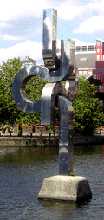
 | Rotating Sculptures | |
Riverside Walk, near the end Hutchings Street, by a block called Hutching's Wharf. These two metallic structures are made to rotate so that the shape of the composition is perpetually changing. However, when the photograph was taken (2005), only one was moving. (See No. 18. on the MAP ) |
||
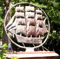 | Schooner. | |
Spindrift Avenue on a corner next to a path leading to Clippers Quay. Clippers Quay was once Millwall Graving Dock, which was a very large dry dock used for ship repairs. Sometime in 2007 the schooner was captured by "pirates" and has now disappeared. (See No. 19. on the MAP ) Sculptor: J.D. Fox. Date: 1989. |
||
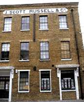 | J. Scott Russell | |
264 � 266 Westferry Road. This used to be the Counting House of the shipbuilding firm whose name is still displayed on its frontage, and which built the Great Eastern. There is a blue plaque nearby commemorating the fact. The building now houses an estate agent. (See No. 20. on the MAP ) |
||
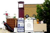 | Self-Storage Artwork. | |
Westferry Road, near Masthouse Terrace. This amusing painted wooden sculpture suggests what you might wish to put into store. The objects include golf clubs, a washing machine, a wheel-barrow and a teddy bear. All of which are realistically portrayed in wood. (See No. 21. on the MAP ) |
||
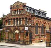 | The Space | |
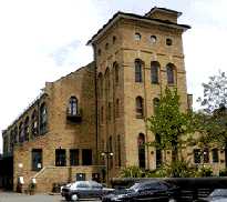
Westferry Road, opposite Claude Street. It was built in 1859 as St Paul's Presbyterian Church in England, its design was strongly influenced by that of Pisa Cathedral. The foundation stone by the side of the front door was laid by the ship builder, Scott Russell, although the writing on it is not very legible. The building is now called "The Space" is used by the performing arts of theatre and cinema. (See No. 22. on the MAP ) |
||
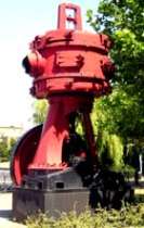 | Technology or Art ? | |
Millwall Dock by the entrance to Millwall Graving Dock. This unlabelled red and black piece is admirably displayed by the waterside. Is it a modern art work or an old piece of dock machinery? The answer is that it was a piece of machinery used to raise the dock gates at the Surrey Docks which has been painted up and brought here to add atmosphere and to improve the architectural landscape. Although an historical piece of technology, it has sculptural lines and composition which compare favourably with some of the art works shown on these pages. (See No. 23. on the MAP ) |
||
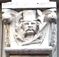 | Top Hat. | |
On the front of 587 Manchester Road. In this row of houses each has a different head carved on the exterior. They range from a devil to royalty and include a policeman and this top-hatted gentleman with a fine moustache. The individuality of these carvings makes a change from the stereotyped designs often found. (See No. 24. on the MAP ) Date: 1889. |
||
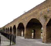 | Railway Viaduct. | |
Just north of Island Gardens DLR station. This viaduct was built in 1871 to carry the branch line of the London to Blackwall Railway. When it first started steam trains were not allowed to travel through the docks for fear of sparks from the engines starting fires. So all trains were horse drawn. Passengers for Greenwich would arrive where Island Gardens Station now is and walk a few yards to the ferry at Ferry Road. (See No. 25. on the MAP ) |
||
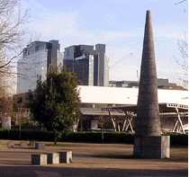 | "Vowel of Earth Dreaming Its Root" | |
Situated at the corner of Mastmaker Road and Marsh Wall. This is accompanied by a number of square blocks which serve as a contrast to emphasize the tall conical shape. (See No. 26. on the MAP ) Sculptress: Eilis O'Connell. |
||
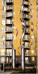
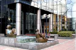 | "Wind of Change." | |
In front of the Exchange Tower, Harbour Exchange Square. The illustration shows two of the four figures in the composition. (See No. 27. on the MAP ) Sculptor: André Wallace. |
||
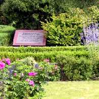 | Workers' Garden. | |
By the side of Westferry Road where it is joined by Tiller Road. This garden is dedicated to the memory of "all those who have lived or worked on the Isle of Dogs." The garden is beautifully kept, but its gates seem to be permanently padlocked, so that one can only look in from the outside and not enter to enjoy its atmosphere. (See No. 28. on the MAP ) |
||
|| Beckton || Bethnal Green || Blackwall || Bow || Bromley-by-Bow || Canary Wharf || Canning Town || Chingford || Cubit Town || Custom House || East Ham || East India Dock || Forest Gate || Higham's Park || Leyton || Leytonstone || Limehouse || Little Ilford || Manor Park || Mile End || North Woolwich || Plaistow || Plashet || Poplar || St George's || St Katharine Dock || Shadwell || Shoreditch || Silvertown || Snaresbrook || Spitalfields || Stepney || Stratford || Upton || Walthamstow East || Walthamstow Village || Walthamstow West || Wanstead || Wapping || West India Dock || Whitechapel || Woodford || |
