| | |
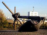 |
Anchor. |
By the side of the Thames just upstream from the Ferry terminal. Note this large anchor was made with just one fluke (See No. 1. on the MAP )
|
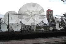 |
BT Dishes. |
Factory Road near to the Ferry terminal.. Showing 16 of the many dishes used there. (See No. 2. on the MAP )
|
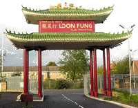 |
Chinese Gateway. |
Factory Road. This ornamental oriental gateway, the height of a two-storey house, advertises Loon Fung Oriental foods which is a Chinese cash and carry wholesale food supplier. (See No. 3. on the MAP )
|
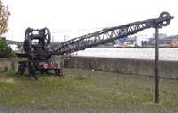 |
Crane. |
By the side of the river Thames just north of the Ferry terminal. This small mobile crane travelling on railway lines was used in the docks for handling some of the smaller loads. (See No. 4. on the MAP )
|
 |
The Foot Tunnel |
Entrance in Pier Road, very close to the terminal of the free ferry. The tunnel was opened by the London County Council in 1912 and was constructed so that the Royal Docks could employ workers who lived South of the Thames. It also provided a means of crossing when the then frequent London fogs prevented the ferries from sailing. Access to the tunnel is either by lift or by stairs. (but the lifts are not always in operation) (See No. 5. on the MAP )
|
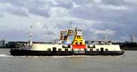  |
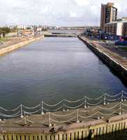
The Free Ferry |
The terminus is at the end of Pier Road and is well signposted on major roads. It was an integral part in London's road system linking the North and South Circular Roads. In 1847 a steam powered ferry service began to operate. This became a free service in 1889, and was run by the Borough of Greenwich, the LCC (later the GLC) and is now part of the wider scheme of TfL, (Transport for London). The London Transport Logo is displayed on the side of the ship's bridge (illustrated here). Each ferry is licensed to carry 200 passengers and 200 tonnes of vehicles. (See No. 6. on the MAP )
 Sailing Times. Sailing Times.
|
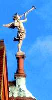 |
The Herald Angel |
On the north side of Royal Albert Dock just south of Beckton Park DLR station there are two deserted and boarded up houses. One of them has this herald on its roof to announce the arrivals to the airport opposite. This was once the central Buffet building and is now grade II listed. (See No. 7. on the MAP )
Sculptor: Philip Jackson.
|
 |
The Triple Lock |
This is the entrance to King George V dock. It was built to permit access to large ocean going liners. One of the largest to use it was the Mauretania. (See No. 8. on the MAP )
|
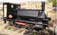 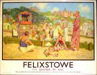 |
North Woolwich Old Station Museum. |
Pier Road. The first station opened here in 1847 was little more than a wooden shack in the midst of farmland. The present station dates from 1854. It became a museum in 1984 after a new station had been opened in North Woolwich. The locomotive shown here was built in 1876 for the Great Eastern Railway. It stands on what used to be a turntable, so that engines could be turned round at the end of the line for the return journey. The museum, which also has old posters and other railway memorabilia, is open between 2.0 pm to 5.0 pm each Saturday, and Sundays (except in December) and with special openings during school holidays. Summer and winter times are different. The poster dates back to the interwar years. (See No. 9. on the MAP )
Poster Artist: W R S Stott.
|
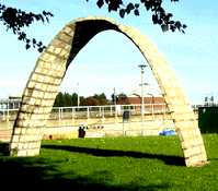 |
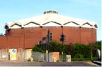
Parabolic Arch, |
Campus of University of East London on the north side of Royal Albert Dock. This pure shape blends well with the architecture of the University buildings. (See No. 10. on the MAP )
|
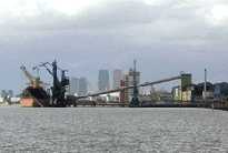 |
Port of London. |
Ship unloading cargo at the Tate and Lyle jetty in Silvertown, upstream of the ferry terminal. This photo was taken in 2006 and shows that the Thames in London is still being used for industrial cargoes. (See No. 11. on the MAP )
|
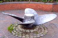 |
Propeller |
Beside the Thames, short way upstream of the Ferry Terminal. (See No. 12. on the MAP )
|
 |
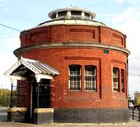
Pumping Station. |
On the roundabout where Albert Way meets Woolwich Manor Way and Royal Docks Road. This was originally constructed to pump water away from the Beckton marshes to allow for development. (See No. 13. on the MAP )
|
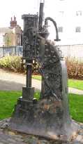 |
Steam Hammer. |
In South East corner of Royal Victoria Gardens, which are off Albert Road. This steam hammer was made in 1888 and was used by the blacksmiths shop of the firm of R H Green & Silley Wier Ltd which was adjacent to the Royal Albert Dock. Their site is now part of London City Airport. (See No. 14. on the MAP )
|
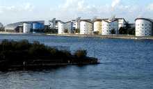 |
University of East London |
By the side of the Royal Albert Dock. The strikingly designed halls of residence are truncated cylinders. The roofs are deliberately angled in this way for the installation of solar panels to provide natural energy. The university overlooks an internationally recognised rowing course in the dock. (See No. 15. on the MAP )
|
 TO READ NAME ~ CLICK FOR PHOTO & EXPLANATION.