SILVERTOWN, CANNING TOWN & CUSTOM HOUSE.
| For centuries, this area was very marshy and was occupied mostly by grazing cattle. Around 1850, S W Silver opened a factory here and built some houses for its workers and the area became known as Silvertown. |
PUT MOUSE OVER  TO READ NAME ~ CLICK FOR PHOTO & EXPLANATION.
CONTENTS | ||
| 1. CEYLON MURAL. | 2. CHARLES II. | 3. "DOCKERS' MEMORIES" |
| 4. EASTLEA COMMUNITY SCHOOL. | 5. THE FLOATING HOTEL. | 6. "THE FLYING ANGEL" |
| 7. THE FOLLY. | 8. THE FOX RESTAURANT. | 9. GAS COMPANY MONOGRAM |
| 10. THE GREEN DOCK | 11. HARLAND & WOLFF GATES. | 12. "LESLIE" AND "ETHEL". |
| 13. MOSAICS OF ST LUKES. | 14. OCTAGON | 15. OLD SWING BRIDGE. |
| 16. PAVILION MEMORIAL. | 17. "THE PORT OF LONDON" | 18. RABBIT CROSSING. |
| 19. ST MARGARET'S CONVENT. | 20. ST MARK'S CHURCH | 21. SCULPTURE. |
| 22. THE SILVERTOWN EXPLOSION. | 23. "BRADLEY STONE" | 24. TAY WHARF. |
| 25. THE THAMES BARRIER. | 26. THE TIDAL BASIN TAVERN. | 27. THE TREACLE TIN |
| 28. THE TUBULAR BULL. | 29. UNDERGROUND ART. | 30. VENTILATORS |
| 31. HMS WARRIOR & THE HAMMERS. | 32. WEST HAM COAT OF ARMS. | 33. WHITE SCULPTURE. |
| 34. SIR CORBET WOODALL | ||
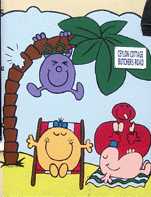 |
Ceylon Mural. |
|
On the front of Ceylon Cottage Nursery in Butchers Road. This is one of three such murals in the style of the Mister Men books. (See No. 1. on the MAP) |
||
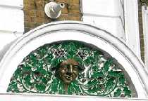 |
Charles II. |
|
On the corner of Barking Road and Oak Crescent. The Royal Oak is so called because Charles II is reputed to have hidden in an oak tree after losing the Battle of Worcester in 1651. After six weeks on the run, he eventually escaped to France, where he stayed till after Cromwell's death. This design is over the pub doorway and shows a head in the middle of oak leaves and acorns. It is unlikely that the face is an exact likeness of Charles II, particularly as it looks rather bibulous and it also has a couple of bunches of grapes in the background. This suggests a link with Bacchus rather than with royalty. Directly above the panel there is the remains of a fitting that was probably attached to a gas lamp. (See No. 2. on the MAP) |
||
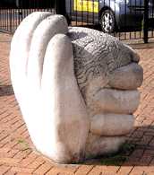 |
"Dockers' Memories." |
|
At the junction of Freemasons Road and Coolfin Road. This shows a pair of hands holding the shape of a human brain. The surface of this shape is covered with various figures of animals, birds and sea creatures. There are also some ships and wheels, for they all represent the dockers' memories. (See No. 3. on the MAP) Sculptress: Paula Haughney. Date 1995. (By the same Sculptress see also "Exotic Birds" and 6 other works, "Heron", "Leslie" and "Ethel", "Lord Mayor's Dragon", "The Passenger", "Ram and Magpie", and "Smiling Beast") |
||
 |
Eastlea Community School. |
|
Off Kimberley Road. This is one of four designs with a botanical theme which have been placed on external walls of this large educational centre. (See No. 4. on the MAP) |
||
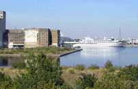 |
The Floating Hotel. |
|
Moored permanently, in the Royal Victoria Dock close to the Excel Exhibition Centre and visible from Pontoon Dock DLR station. Called the Sunborn Yacht Hotel it looks less like a yacht than a large cruise liner. (See No. 5. on the MAP) |
||
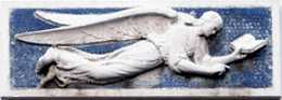 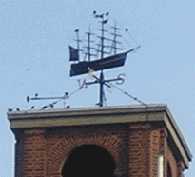 |
"Flying Angel" |
|
287 Victoria Dock Road. This building was erected for use by the Anglican Mission to Seamen, but is now a block of small flatlets. The angel no doubt arrived with the Mission (as angels usually do). The sculpture has a blue mosaic background. This shows that when flying, angels prefer to read rather than to watch inflight films or videos. Note also the weather vane on the roof which is in the form of a fine four masted sailing vessel. (See No. 6. on the MAP) |
||
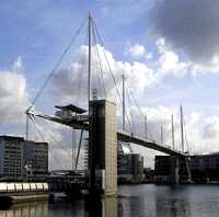 |
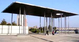
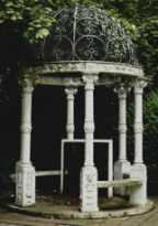
The Folly. |
|
Spanning Royal Victoria Dock. Pevsner refers to this bridge as "an apparent folly". There was clearly an easier and less expensive way to arrange for pedestrians to cross the dock. The immense height of the walkway was unnecessary, because when it was built in 1999, the dock had long ceased to handle large ocean liners. The tallest vessel to pass under it now is a small yacht. But the bridge does look impressive. Pedestrians cross by going up in a lift attached to the end tower and then use the high walkway and descend by another lift at the far side. (See No. 7. on the MAP) |
||
 |
Fox Restaurant. |
|
On the corner where Victoria Dock Road meets Connaught Bridge and below the level of the road. On the walls of the building there are two carvings into the brickwork. The building was originally the Connaught Tavern, and in 1881 when it was built, catered for sea travellers via the docks. (See No. 8. on the MAP) |
||
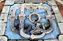 |
Gas Company Monogram |
|
On the ground outside the London Gas Museum, Twelvetrees Crescent. This is raised at the back so that it is easier to see. The building was previously the offices of the Gas, Light and Coke Co. The Museum can be visited on week days, but only after making an appointment in advance. (See No. 9. on the MAP) |
||
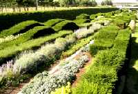 |
The Green Dock |
|
In Barrier Park, by the Thames Barrier. Entry can be made along a walkway from Pontoon Dock DLR station. The gardens of this park are laid out to an unusual design. A long narrow area like a dock has been dug out and instead of filling it with water it has been turned into a garden and called "the Green Dock". The hedging plants are trimmed to imitate the waves of the Thames and the herbaceous plants are in long parallel straight lines. In warm weather there is a children's fun area with a series of water fountains, which vary in height, for young children to splash through. (See No. 10. on the MAP) |
||
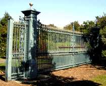 |
Harland & Wolff Gates. |
|
In Lyle Park, off Bradfield Road. These were originally the gates of the main entrance in Woolwich Manor Way to the yards of Harland & Wolff, a famous firm of shipbuilders and repairers. The firm occupied these premises from 1924 to 1972. These gates now are a gateway to nowhere but yet seem to blend into the park forming an eye-catching feature. (See No. 11. on the MAP) |
||
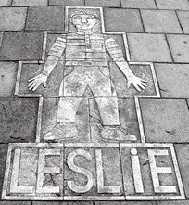 |
"Leslie" and "Ethel". |
|
Freemasons Road, in the paving stones between Ethel Road and Leslie Road there are two carved portraits of Leslie and Ethel. They are larger than life portraits of children which are carved in relief. There is also a group of smaller pictures with a nautical theme. This is an unusual way to mark the names of streets. It makes one think that as so many roads are named after prominent people, how much more interesting it would be to have either a pictures or brief information about them next to the road signs. (See No. 12. on the MAP) Sculptress: Paula Haughney. Date 1995. (By the same Sculptress see also "Dockers' Memories", "Exotic Birds" and 6 other works, "Heron", "Lord Mayor's Dragon", "The Passenger", "Ram and Magpie", and "Smiling Beast") |
||
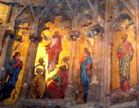 |
Mosaics of St Lukes. |
|
St Luke Square. St Luke's church was deconsecrated in 1985 and is now called St Luke's Centre. Much of the interior has been converted to office space for social work, but the west end holds a café and the east end is (in 2006) being prepared for a meeting room. The Walls in this latter room are covered with a sequence of magnificent mosaics depicting Jesus and his disciples, together with a number of angels. These mosaics, which date from about 1890, are very large (4 – 6 metres high) and richly coloured with gold-coloured tessera forming the backgrounds. It is hoped to restore these mosaics soon; but it is not certain whether they will be on public view. Although St Luke's no longer has a congregation, it's football club is still going strong. (See No. 13. on the MAP) |
||
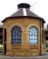 |
Octagon. |
|
The west end of the Royal Albert Dock, almost below the Connaught Bridge. This little building covers the pumping shaft for the railway tunnel which passes below and dates from 1878. The pump was used to extract any water that seeped into the tunnel. Nearby, there are some benches where you can sit and get an excellent free view of the comings and goings from the London City Airport. (See No. 14. on the MAP) |
||
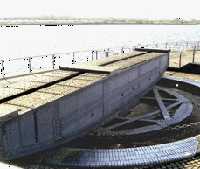 |
Old Swing Bridge. |
|
Beside the Ramada Hotel almost under the Connaught Bridge. These are some of the workings which used to swing the old bridge open and shut. (See No. 15. on the MAP) |
||
 |
Pavilion Memorial. |
|
In Barrier Park at the southern end of the green dock. This pavilion shelter was put up in memory of the victims of war in the Borough of Newham. Note that the undulating stonework which provides seating continues the wave motion of the planting in the green dock. (See No. 16. on the MAP) |
||
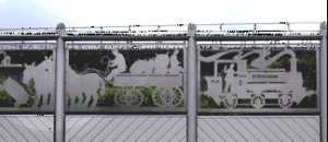 |
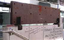
"The Port of London" |
|
By Prince Regent DLR station in Victoria Dock Road. This illustration shows just two out of fifty panels which make up a very long frieze illustrating scenes in the Royal Docks and the way that life in the area has changed over the centuries. The pictures are in the form of silhouettes and appear almost Victorian in their styling. But the subject matter dates from the 17th to the 20th centuries and the frieze is lively, interesting, informative and amusing. . (See No. 17. on the MAP) Artist: Brian Yale. Date: 1995. (See also "Horses" and "Birds" by the same artist.)
|
||
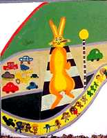 |
Rabbit Crossing. |
|
On the front of Abrahams Nursery in Radland Road. This is one of three paintings on the front of the building. Should we refer to this mural as showing a Zebra crossing or a Rabbit crossing? (See No. 18. on the MAP) |
||
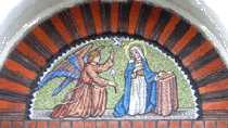 |
St Margaret's Convent. |
|
The convent is on the corner of Falcon Avenue and Chargeable Street. This mosaic over the door is a small but richly coloured mosaic. (See No. 19. on the MAP) |
||
 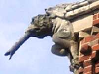 |
St Mark's Church. |
|
North Woolwich Road. This building is now occupied by Brick Lane Music Hall. It was built originally in 1860 as highly decorative church with elaborate patterning in the brickwork and roof tiles. The building was restored in the 1980s after having been left empty for some years. The owl and the gargoyle with a water spout in its mouth are clearly visible from the road. (See No. 20. on the MAP) |
||
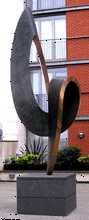 |
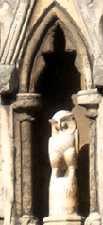
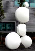
Sculpture. |
|
At the top of a flight of stairs leading off Mace Gateway and in front of Capital East Apartments just north of the Royal Victoria Dock. This abstract sculpture has no accompanying notice giving the title of the work or name of the artist. (See No. 21. on the MAP) |
||
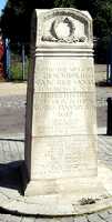 |
The Silvertown Explosion. |
|
This monument is situated by the side of North Woolwich Road, directly under the Docklands Light Railway and outside the entrance to Stone Centre or Tile Centre. In 1915, during World War 1, when armaments were a first priority, it was decided to use an empty chemical factory for making TNT explosives. In January 1917 there was an enormous explosion which demolished the factory, damaged 900 houses, killed at least 73 people and injured 400 others. The resulting fire ignited a gas holder in Greenwich, on the other bank of the Thames. The sound of the explosion was heard 100 miles away in Southampton. This monument was erected by the firm and only lists those victims who were employed in the factory together with members of staff killed in two world wars. (See No. 22. on the MAP) |
||
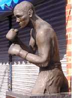 |
Bradley Stone. |
|
Outside the Peacock Gym in Caxton Street North, near to the junction with Victoria Dock Road. In April 1994, Bradley Stone (1970 – 1994) was boxing in a contest at York Hall in Bethnal Green. Stone walked out of the ring apparently unharmed, but a few hours later at his girl friend's house he collapsed and two days later he died. His fans clubbed together to pay for this statue which is placed outside the gym where he trained. There is also a road in Beckton named after him. (See No. 23. on the MAP) Sculptress: Ann Downey. Date: 1995. |
||
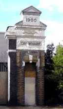 |
Tay Wharf. |
|
North Woolwich Road, Eastern end. This entrance to Tay wharf has been preserved and partly renovated. It is dated 1900. This entrance once led into the jam factory of Keiller and sons who occupied the wharf from 1880-1997. This was an ideal site because the main ingredients were close at hand. The fruit could be unloaded straight out of the ships and the sugar came from Tate and Lyles refinery almost next door. (See No. 24. on the MAP) |
||
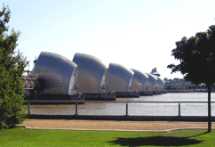 |
The Thames Barrier. |
|
In January 1953, there were disastrous floods along the Essex coast and along the Thames estuary, when Gales combined with a tidal surge due to a water build-up in the North Sea. On that occasion 58 people were drowned on Canvey Island and 11,500 were made homeless. While in Silvertown, the water broke through the defences and 1130 homes were flooded, many of them being on the Keir Hardie Estate. Everything possible was used in the rescue operations and even the pleasure boats from the pond in Barking Park helped to evacuate people from the upper floors of flooded houses. These events provoked a serious rethink of the whole problem. Completed in 1982, the barrier was intended to protect properties which lay upstream of it from future damage. With global warming causing a gradual rise in sea level, it has already had to be raised much more frequently than was originally anticipated. (See No. 25. on the MAP) |
||
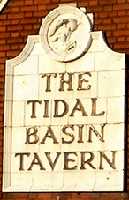 |
The Tidal Basin Tavern. |
|
On the roundabout in Mace Gateway. This Public House is still standing although (in 2006) it is boarded up, and serves as a reminder of the time when arrivals in the docks were regulated by the tides. (See No. 26. on the MAP) |
||
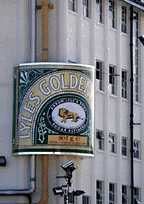 |
The Treacle Tin. |
|
On a corner of the Tate and Lyle's factory building, directly facing the West Silvertown DLR station. This golden syrup tin is a giant version of something that was once a very familiar item in most British kitchens. The firm Tate & Lyle was formed by an amalgamation of two sugar refineries in Newham each founded about 1880. Initially Tate specialised in producing cube sugar while Lyle, whose sugar refinery was on this site, was best known for his golden syrup. The trademark picture of the lion with a swarm of bees was taken from the Biblical story of Sampson's riddle. (Judges chapter 14, v. 14.) (See No. 27. on the MAP) |
||
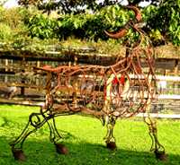 |
The Tubular Bull. |
|
In a paddock on Newham City Farm, entrance in Stansfield Road. This farm has a good collection of well cared for farm animals and birds, together with a number of other animals, which are children's favourites. There are also several farm implements on show. Open from Tuesdays to Sundays, 10.0 – 5.00 in Summer and 10.00 to 4.00 in Winter. Admission is free, but donations are welcomed. The sculpture is thought to have been made for display at St Katharine's Dock by a local artist, but ended up at the more suitable location at this farm. (See No. 28. on the MAP) |
||
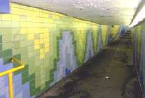 |
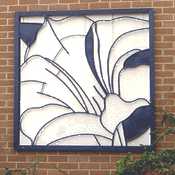
Underground Art. |
|
The pedestrian underpass linking Fife Road and Douglas Road and going under Newham Way. These decorative tiles cover both walls and stretch a long way. (See No. 29. on the MAP) |
||
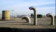 |
Ventilators. |
|
Under Connaught Bridge on the South side of Royal Albert Dock. The photo shows four ventilator for the railway tunnel which runs below the docks at this point. To the rear left is one of the original ventilation shafts of 1878. In the foreground are three modern equivalents. There is another example of the old shafts near the old bridge turning mechanism. (See No. 30. on the MAP) |
||
 |
HMS Warrior & The Hammers. |
|
Canning Town Station. By the side of the stairway going down from the entrance in Silvertown Way which leads to the below-ground ticket hall. HMS Warrior was the first of the Royal Navy's ocean-going ships with an all-metal hull and was built by the Thames Ironworks and Shipbuilding Company in 1860. She had three masts for sails, two funnels and a screw propeller. All the three latter were retractable to facilitate sailing. This shipyard occupied a large area at the mouth of the River Lea. Up till then, most of the injuries received by ship's gun crews were caused by flying wood fragments during battle. The iron hull greatly reduced this. Other countries soon copied this new innovation. Apart from this plate, the remainder of HMS Warrior can now be seen at Portsmouth, after having been lovingly restored by some dedicated enthusiasts in Hartlepool. Two of the hammers used to rivet the iron plates were used as the logo of the Thames Ironworks football club. This club later amalgamated with two other local clubs to form West Ham United FC, which today is often referred to as "The Hammers". Originally West Ham were called "The Ironsiders" and it was East Ham who were the Hammers. As West Ham flourished, the media rewarded the by giving them East Ham's name. These hammers also appeared on the coats of arms of both West Ham and of Newham. (See No. 31. on the MAP) |
||
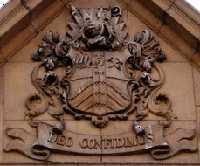 |
West Ham Coat of Arms. |
|
On the front of the Custom House Public Library in Prince Regent Lane. Two of the symbols on the shield link with the Silvertown area, The sailing ship top right is symbolises the docks and two similar craft are illustrated on this page. (See Flying Angel and Fox Restaurant) While the crossed hammers represent shipbuilding, (see HMS Warrior, above, and Harland & Wolff Gates.) (See No. 32. on the MAP) |
||
 |
White Sculpture. |
|
On the corner outside the Twelvetrees Business Park Office. (See No. 33. on the MAP) |
||
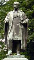  |
Sir Corbet Woodall |
|
In the garden next to the London Gas Museum. Sir Corbet Woodall (1841 – 1916) was a structural engineer who built the nearby grade II listed gas holders and later became chairman of the Gas, Light and Coke Co, one of the largest suppliers of gas before nationalisation. He also built the gasholders at the gasworks end of the Oval Cricket ground. He was an enlightened employer who was one of the first to introduce a partnership scheme for his workers. Woodall is shown holding his glasses and facing the war memorial (shown in the right hand photo) to members of the company staff who died in the two world wars. The sculptor's usual signature on his works (such as that on Florence Nightingale statue in Waterloo Place, SW1) is G A Walker, but if you look just below the subject's right foot you will see that in this case he has added an S, to read GAS Walker. By going out the side gate of the garden you can get a close up view of one of the Gas holders (dated 1872) and can see how they expanded by concentric cylinders rising up to hold increased volumes of gas. (See No. 34. on the MAP) Sculptor: George Arthur Walker (1861-1939) |
||
OTHER AREAS COVERED:-
|| Beckton || Bethnal Green || Blackwall || Bow || Bromley-by-Bow || Canary Wharf || Canning Town || Chingford || Cubit Town || Custom House || East Ham || East India Dock || Forest Gate || Higham's Park || Leyton || Leytonstone || Limehouse || Little Ilford || Manor Park || Mile End || Millwall || North Woolwich || Plaistow || Plashet || Poplar || St George's || St Katharine Dock || Shadwell || Shoreditch || Snaresbrook || Spitalfields || Stepney || Stratford || Upton || Walthamstow East || Walthamstow Village || Walthamstow West || Wanstead || Wapping || West India Dock || Whitechapel || Woodford || |