PUT MOUSE OVER  TO READ NAME ~ CLICK FOR PHOTO & EXPLANATION.
CONTENTS | ||
| 1. Bakers' Alms Houses | 2. Bandstand | 3. Beaumont School Mural |
| 4. Cat | 5. Church Road School | 6. Clock |
| 7. Damsel Fly Seats | 8. Etloe House & the Cardinal | 9. Farmer Road School |
| 10. Food | 11. Fountain | 12. Lammas Land Protest |
| 13. Lea Mills Mosaic | 14. Library Tiles | 15. "Lotus" |
| 16. Meridian House | 17. Meridian Markers | 18. Cricket Pavilion |
| 19. Railway Track | 20. Riverley School Mural | 21. "Runner" |
| 22. St Mary's Church | 23. "Technology" | 24. Old Tombstone |
| 25. Town Hall Heads | 26. Walnut Tree House | 27. King William IV |
| 28. Willow Brook Mural | ||
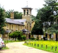  |
Bakers Alms Houses |
|
Lea Bridge Road. This attractive court of almshouses was put up by the London Master Bakers' Benevolent Institution in 1866. The carving of the young boy gathering in corn for the bakers' loaves is too far away to be easily seen from outside the security fence. (See No. 1. on the MAP ) |
||
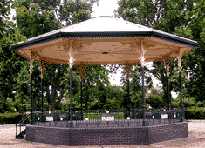 |
Bandstand |
|
Coronation Gardens, Leyton High Road. The name is due to the fact that the land was purchased for the gardens in 1902, which was the year of the coronation of King Edward VII. The park was not opened until 1905. (See No. 2. on the MAP ) |
||
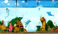 |
Beaumont School Mural |
|
Detail from a mural on the boundary wall of the playground of Beaumont Primary School. This can be seen from the footpath that links Burchell Road with Skelton's Lane. This brightly coloured mural shows an underwater view of tropical marine life featuring fish and plants. (See No. 3. on the MAP ) |
||
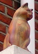 |
Cat. |
|
655 High Road Leyton. Perched permanently on the frontage of Midland Vetenary Surgery and balanced by a dog sitting on a matching pedestal. (See No. 4. on the MAP ) |
||
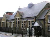 |
Church Road School |
|
Church Road. Across its front this proclaims that it was founded in 1876. It was probably funded in part from compensation paid in the 1870s by the Great Eastern Railway company because they were using some of the Lammas Land for their new railway. (See No. 5. on the MAP ) |
||
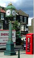 |
Clock |
|
On a traffic Island at the junction of Church Road and Lea Bridge Road. This is one of several similar clocks erected in the Lea Valley to celebrate the Millennium in 2000, which were probably purchased wholesale. There is a similar one in Highams Park. (See No. 6. on the MAP ) |
||
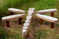 |
Damsel Fly Seats |
|
In the Waterworks Nature Reserve, entrance off Lea Bridge Road via the car park and visitors centre. Cross a footbridge and this is in the wildlife garden area to the right of the path in front of you. This group of seats for visitors is designed to represent one of the damsel flies which frequent the ponds of the old waterworks. There are also hides from which visitors may watch water fowl and other wild life. The use of these is free for the general public. Enquire in the visitors centre. (See No. 7. on the MAP ) |
||
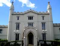 |
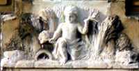
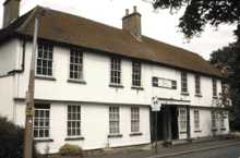
Etloe House & The Cardinal. |
|
The west side of Church Road next to Marsh Lane. Parts of this house dates from 1760 but it has been considerably altered in appearance. From 1856 this was the country house of Cardinal Nicholas Wiseman (1802-65). Wiseman became well known after he delivered a series of lectures showing that science and religion were not in conflict. In 1850, he was made a cardinal and was appointed as Archbishop of Westminster, the first to hold this title. The appointment together with an article he published expressing the hope of a growth in the number of conversions to Catholicism caused fear and indignation among Protestants. The result was a Parliamentary bill restricting the use of the term archbishop to those of the established church recognised by English law. (See No. 8. on the MAP ) |
||
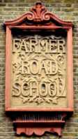 |
Farmer Road School |
|
Farmer Road. One of the original carved name plates on the school walls designed in the style of the Arts and Crafts movement of Edwardian times, (See No. 9. on the MAP ) |
||
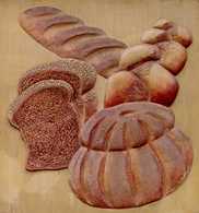 |
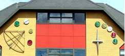
Food |
|
On the front wall of Tesco in High Road Leyton. One of 15 reliefs depicting the various foods sold within the supermarket. The textured surfaces and the 3D effect of the reliefs make the sculptures seem very lifelike. (See No. 10. on the MAP ) Sculptor: John McKenna
| ||
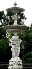 |
Fountain |
|
Coronation Gardens, Leyton High Road. This fountain erected in 2000 is a replica of one originally put up in the 1920s. The two putti have been standing here holding up this heavy dish for some years now, patiently waiting for someone to switch on the water. (See No. 11. on the MAP ) |
||
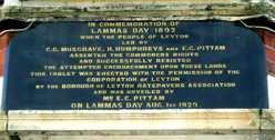 |
Lammas Land Protest |
|
Notice fixed to the front of "The Cottage" which is at the end of Marsh Lane. The notice states:
There is a growing feeling that the Defence Committee should be revived because of the high handed actions of the 2012 Olympics Committee in the treatment of the green areas in the Lea Valley. See http://www.metamute.org/en/Of-Lammas-Land-and-Olympic-Dreams for more details of this. (See No. 12. on the MAP ) Date: Lammas Day, August 1st 1929. |
||
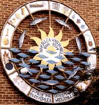 |
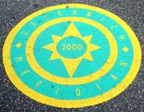
Lea Mills Mosaic |
|
One of two large circular mosaics in Oliver Road at the junction with Walnut Road. This commemorates the mills in the Lea valley which are thought to have been here from the 11th to the 19th centuries. Round the circumference are goods produced here. The one exception is the football, seen here caught between two fishes, which arrived there in the 21st century. (See No. 13. on the MAP ) |
||
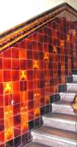 |
Library Tiles. |
|
Carnegie Public Library in Lea Bridge Road. This grade II listed building was put up in 1905, The original tiled staircase leading to the first floor is of the same date. See also the philanthropy and bust of Andrew Carnegie. (See No. 14. on the MAP ) |
||
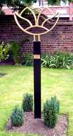 |
"Lotus" |
|
In front garden of Etloe Hiouse in Church Road. (See No. 15. on the MAP ) Sculptor: Jack Gardner. Date: 2007. (See also "Allum" , Fleeing Woman and Tao Column by the same artist) |
||
 |
Meridian House |
|
One of the buildings of Leyton Sixth Form College, Essex Road. On the front is a quadrant, the mediaeval forerunner of a sextant used for navigational position finding at sea. When a navigator aimed the viewing arm of the quadrant at an object in the sky a weight hanging by a thread suspended from the apex would hang past a scale graduated in degrees and this gave the angle of its height in the sky of the object and this in turn gave their position. For example, the angle between the horizon and the Pole Star equalled the latitude of the ship. If the meridian markers in the pavements (see next entry) are accurately placed then this building is a few yards to the west of the meridian. (See No. 16. on the MAP ) |
||
 |
Meridian Markers |
|
One of several similar markers set into the pavement at the point where the street crosses the Greenwich Meridian. Examples of these may be seen outside 65 Peterborough Road, 34 James Lane, 1 Cromer Road, 99 Nottingham Road and in Canterbury Road, etc. They are marked GREENWICH MERIDIAN and dated 2000. There is also an older brass marker set into the pavement outside 30 Exeter Road. Two similar examples of the latter can be seen in Walthamstow. (See No. 17. on the MAP ) |
||
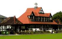 |
Cricket Pavilion |
|
By the sports ground beside Leyton High Street. From 1885 for nearly 50 years this was the Essex Cricket Club's home ground. The River Lea then marked the Essex border. Previously, the club had been based at Brentford. It was on the Leyton ground in 1932, that the Yorkshire batsmen Herbert Sutcliffe and Percy Holmes hit a record-breaking first wicket partnership of 555. This record stood for 44 years. (See No. 18. on the MAP ) |
||
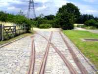 |
Railway Track |
|
Waterworks Nature Reserve entrance just off Lea Bridge Road through the car park and visitors centre. Cross a footbridge and follow a footpath in front of you and you will come to these rails. Formerly this whole area was the property of the East London Waterworks Company. Following a cholera outbreak, in 1852, work began to create a series of filter beds to purify the water supply. The water was pumped between these beds by steam driven pumps. The coal for the steam engines was carried by these rails. (See No. 19. on the MAP ) |
||
 |
Riverley Mural |
|
Mural on a rear wall of Riverley Primary School. This is often visible from Shaftesbury Road (off Park Road), when some large wooden gates are open. On the bottom of the mural are the words "Welcome to Church Mead". The school name preserves an old spelling of the river Lea. (See No. 20. on the MAP ) |
||
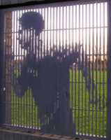 |
"Runner" |
|
Temple Mills Lane. The brick wall enclosing a sports field often used by Leyton Orient B football team. There are twenty pictures displayed in gaps in the brickwork. The black and white pictures are formed by the shaping of the vertical metal bars. By filling the gap between bars produces black while reducing the width of bars creates white. By clever variations in width of each of the bars, a picture like the one shown here is produced. The pictures are on the theme of sport and the spectators. The artist wished to show the sporting events taking place inside the walls and used this method to give the impression of movement. One must hope that when this sports field is incorporated into the 2012 Olympics complex these art works will still be featured. (See No. 21. on the MAP ) Artist: William Bruce. Date 1997. |
||
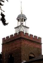 |
St Mary's Church |
|
Church Road, by the junction with Oliver Road. The clock that sits on the tower looks architecturally out of place. This is because it came from Leyton Great House. There had been a church here from at least Henry II's reign when it was given by Gilbert de Montfichet into the care of Stratford Langthorne Abbey. It was the referred to as the Church of Ley. Leyton Great House was the largest mansion in the area and was built about 1700 in the style of Sir Christopher Wren. It was sold to developers in 1881 and demolished in 1905. (See No. 22. on the MAP ) |
||
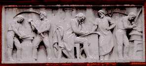 |
Technology |
|
In Adelaide Road behind the Town Hall. This was designed to illustrate the work of the Technical Institute. In the middle is placed the study of technology and science which is at the centre of craftsmanship on the right and heavy industry on the left. (See No. 23. on the MAP ) Date: 1895. |
||
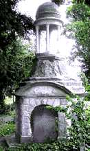 |
Old Tombstones |
|
In the graveyard of St Mary's church, Church Road. There are several large tombstones dating from the 18th and 19th century. At that time, there were a number of rich people who had country residences in Leyton. Although they could not take their wealth with them when they died, their families could still use some of it to build large elaborate tombstones. This shows the grave of Benjamin Moyer who died in 1759, who in 1738 was master of the Mercers Company and owned a house near the present Hainault Road. Note the skull carved on the gravestone. Note also the similarity in design of the top part of this monument to the clock on the church tower. (See No. 24. on the MAP ) |
||
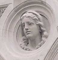 |
Town Hall Heads. |
|
On the side wall of the building in Adelaide Road there are five individually carved heads. These appear to depict people from different ages of history. (See No. 25. on the MAP ) |
||
 |
Walnut Tree House |
|
500 High Street at the corner of Jesse Road. Although it may not appear so, this is the oldest house in Leyton. Parts date from the 15th and 16th centuries. Note how the upper floor overhangs the lower one. The building has a wooden frame and the interior still has some Tudor fireplaces and a wall painting from the 16th century. The house however has been much altered over the centuries. When the house was leased to a new occupier in 1813 the latter was required to preserve a large walnut tree in the garden. A previous lease of 1804 stated that the house must not be used as a school, a tavern or a factory. In 1870 it did become a school and a notice now says it is a private club, where presumably drinking takes place; but it has not yet been used as a factory. (See No. 26. on the MAP ) |
||
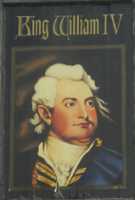 |
King William IV |
|
Pub sign on the corner of William Street and High Road Leyton. William IV, known as "the Sailor King", reigned from 1830-37. He served in the navy from 1779-1828 ending up as Lord High Admiral. He was not survived by any of his legitimate children, so was succeeded by his niece, Victoria. (See No. 27. on the MAP ) |
||
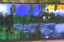 |
Willow Brook School Mural |
|
Behind Willow Brook Primary School, Church Road. The mural is on the back wall of the playground and is visible from Marsh Lane. The mural shows elephants and other tropical creatures at a waterhole. (See No. 28. on the MAP ) |
||

OTHER AREAS COVERED:-
|| Beckton || Bethnal Green || Blackwall || Bow || Bromley-by-Bow || Canary Wharf || Canning Town || Chingford || Cubit Town || Custom House || East Ham || East India Dock || Forest Gate || Higham's Park || Leytonstone || Limehouse || Little Ilford || Manor Park || Mile End || Millwall || North Woolwich || Plaistow || Plashet || Poplar || St George's || St Katharine Dock || Shadwell || Shoreditch || Silvertown || Snaresbrook || Spitalfields || Stepney || Stratford || Upton || Walthamstow East || Walthamstow Village || Walthamstow West || Wanstead || Wapping || West India Dock || Whitechapel || Woodford || |