SPITALFIELDS.
| The name Spitalfields was derived from St Mary's Spital (Hospital) which was founded in 1197. Recent excavations have uncovered the Charnel House, which can be seen in Bishop's Square. Many centuries before the hospital, the Romans used part of the area as a burial ground, and a decorated lead coffin found here is on display in the Museum of London. |
PUT MOUSE OVER  TO READ NAME ~ CLICK FOR PHOTO & EXPLANATION.
CONTENTS |
||
| 1. Bakers (Ceramic) | 2. Bishop's Square Archaeology | 3. Border Stone |
| 4. Boundary Bollard | 5. Brick Lane Mosaics | 6. Charnel House |
| 7. Christ Church | 8. Church School | 9. "Cnihtengild" |
| 10. "Eye-1" | 11. Fashion Street Market | 12. Mark Gertler |
| 13, Kindertransport Memorial | 14. "Lines of Communication" | 15. London Jamme Masjid. |
| 16. Match Girls | 17. Princelet St. Synagogue | 18. "Rebellion." |
| 19. Roundels | 20. St. Botolph's Hall | 21. Severs House |
| 22. Shoreditch Borough Street Lamp | 23. Silk Weavers' Houses | 24. Old Shop & Pre-Tolpuddle Martyrs |
| 25. Jewish Soup Kitchen | 26. "Spitalfields Journey | 27. Spitalfields Market Gates |
| 28. Spitalfields Market | 29. Truman's Brewery | 30. "Vortex." |
| 31. Wesley's Mother | : | : |
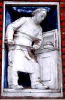 |
The Bakers. |
|
On the wall of 12 Widegate Street, E1. There is series of four ceramic reliefs depicting the work of a bakery. They show:
Artist: P. Lindsey Clark, 1926. |
||
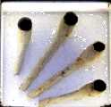  |
Bishop's Square Archaeology. |
|
Set among the paving stones in Bishop's Square, there are 12 smaller glass-covered squares. In these are displayed some of the artefacts found when archaeologists searched before the recent building development here. The two examples shown here are clay pipes dating back to the 18th century and a decorated tile showing the figure of an angel. (See No. 2. on Map) |
||
 |
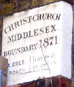
Boundary Bollard. | |
At the corner of Brick Lane and Hanbury Street. This bollard has written on it:
(On the Bollard the T is much closer to the dot underneath it than is probably shown on your monitor.) The inscription therefore shows that it was the boundary of the parish of Christ Church in Middlesex and that that it was set up in 1819. Christ Church is no longer in Middlesex for as London spread, Middlesex shrank. This bollard seems to have stood on this busy street corner for nearly two centuries and must surely bring credit upon generations of drivers who failed to knock it down. Of course, the credit may be due to the builders who fixed it so securely, that it has always come off best in any collision which did occur. (See No. 4. on Map) |
||
 |
Boundary Stone. | |
42 Brushfield Street. Like the Bollard, this marks the parish boundary. Many parishes had the custom of beating the bounds which was an annual procession round the parish boundaries and was a means of teaching both adults and children the extent of their parish. Beyond this point the ground belonged to the Guild of Artillery. (See under Cnihtengild) A little further down Brushfield Street is a pub called The Gun. This is near to where the Honourable Artillery Company, founded by Henry VIII in 1537, had its barracks. (For the stone see No. 3. on Map) |
||
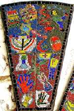 |
Brick Lane Mosaics. |
|
There is one set of mosaics on each side of the road in the northern part of Brick Lane, near the railway bridge. Each consists of six panels arranged in a semicircle. The panel illustrated here has been designed to show the range of the religious backgrounds in the local population, and symbolically shows them side by side. These mosaics were produced by the children of St Anne's and Thomas Buxton Primary Schools. (See No. 5. on Map) Date: 1995, but moved here from Bishopsgate in 1998. |
||
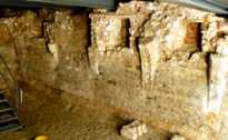 |
Charnel House. |
|
Beneath the pavement of Bishops Square, Spitalfields, and can be seen through glass. If you go down some steps you can the remains of a building from about 1320, which was used for storing the bones of the dead. You can see a large vaulted chamber behind the ruined walls in this illustration. This was part of the St Mary Spital complex which included an Augustinian priory, an infirmary, a church and a cemetery. The priory was closed in 1539, the bones removed and a house built above the site. The Charnel house was rediscovered in 1999. This Spital (Hospital) gave rise to the name Spitalfields. It is thought that parts of the masonry may date back to the 12th century. Long before the Charnel House was built, the Romans were using the area as a burial ground. A Roman lead coffin was found near this site which contained the body of a woman. This sarcophagus is now in the Museum of London. (For the Charnel House see No. 6. on Map) |
||
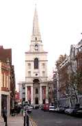 |
Christ Church. |
|
An unmistakable landmark in Commercial Street opposite Spitalfields market. This elegant building was designed by Nicholas Hawkesmoor. By about 1700, East London already had a number of non-conformist churches and congregations. This caused concern among the Anglican establishment. In 1711, a Tory government allocated funds to build 50 new churches to be erected round London. Christ Church, consecrated in 1729, was one of the twelve that were eventually built. Two others in the East End are St George-in-the-East and St Anne's in Limehouse. The Church is open for visitors on Tuesdays from 11.0 am to 4.0 pm. There is no charge for individual visitors but it is hoped that they will give a donation. (See No. 7. on Map)
|
||
 |
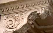
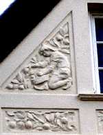
Christ Church Primary School. |
|
Brick Lane. Founded in 1708, the school moved into a new building in 1782. The carving shows the original building, which was built close to the church. Note the roundel in the pavement in front of the school. It has the same Children as on this carving, but they are surrounded by a ring of pencils. ( For the school see No. 8. on Map. See also Roundels) |
||
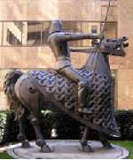 |
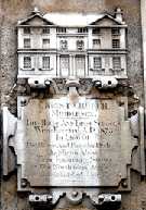
"The Cnihtengild" |
|
A beautiful and impressive statue at Cutlers Gardens, 3-11 Devonshire Square. King Edgar (944-975) made an agreement with a group of 13 knights that he would give them land near to this spot on condition that they would each engage in three combats, one on the ground, another on water and the third below ground. The Cnihtengild was therefore the old way of saying a guild of knights. King Edgar was also responsible for bringing St Dunstan to Britain. The grassy land in this area, which was outside the city walls, continued to be used for military purposes for many years. In the 16th and 17th centuries, archery was practised here and muskets and cannons were fired and tested near here on land owned by the Guild of Artillery (see Boundary Stone). This explains why two of the nearby streets are called Artillery Lane, Gun Street and that there is also a public house called The Gun. (See No. 9. on Map) Sculptor: Denys Mitchell, date: 1990 |
||
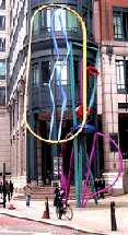 |
"Eye-1" |
|
A large metal sculpture situated in North Folgate, outside the Bishopsgate Arcade. Bishopsgate, North Folgate, Shoreditch High Street and Kingsland Road were all originally part of Ermine Street, the main Roman road from London Bridge to Lincoln and York. Could that be the reason for the two blue lines running up the centre of the sculpture? (See No. 10. on Map) Sculptor: Bruce McLean. 1993. |
||
 |
Fashion Street Market. |
|
Along the South side of Fashion Street the architecture is in a Moorish style. This was built in 1905 to be an arcade of retail outlets, but the scheme soon collapsed and the buildings are now occupied by various commercial businesses. (See No. 11. on Map) |
||
 |
Mark Gertler. |
|
Roundel set in the pavement in front of 32 Elder Street. The artist, Mark Gertler (1891- 1939) lived in this house, now marked by a blue plaque. This roundel shows a detail from his painting entitled The Merry-Go-Round , 1916, which is in the Tate Britain, London. The work shows his strong primitive style and expresses his anti-war feelings. (See more about the Roundels, and for the house see No. 12. on Map) Designer of roundel: Keith Bowler. 1995. |
||
Kindertransport Memorial. |
||
Situated almost in E1 at the Liverpool Street entrance of Liverpool Street Station. In 1938, after pressure was placed upon it, the British government finally gave permission for up to 10,000 Jewish refugee children to enter the country, provided that they would not be a burden to the state. Arrangements were put in place to bring out Jewish children from Nazi Germany and Austria. Between December 1938 and August 1939, 9534 children were thus saved from the Holocaust. These children never saw their parents again. The memorial is placed at this station, because this is where the children arrived in London on the boat train from Harwich. This sculpture of a group of children replaces that of young girl, which stood here for several years, however, that asylum-seeker has now been expelled back to Germany. The adage quoted in the notice at the base of sculpture is: "Whosoever rescues a single soul is credited as though they had saved the whole world." (Talmud, Baba Batra 11a.) (See No. 13. on Map) Sculptor: Frank Meisler, Arie Ovadia. September 2006. |
||
 |
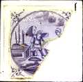
"Lines of Communication" |
|
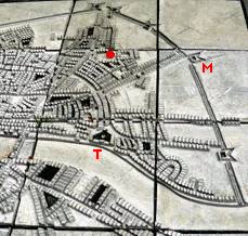
Bishop's Square. Detail from a three-dimensional map showing the defences erected by the Parliamentary forces to protect London from the Royalists during the civil war of 1642 - 1651. The model is based upon a map of 1738. On the model a silver ball shows the position of Bishops Square but this has been coloured red in the photo. The part shown here is the eastern section. The Tower of London is marked with a T and the fort at Mount Terrace with an M. (See No. 14. on Map) Artists: Paula Craft & John Pegg. 2008. |
||
 |
London Jamme Masjid. |
|
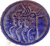
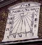
The name means Great Mosque. It stands on the corner of Brick Lane and Fournier Street. This building is the architectural equivalent to the Vicar of Bray. It has been used as a place of worship by the various waves of new immigrants to the area. This building began its life in 1743 as a Huguenot Church. After brief use by a Christian conversionary movement aimed at trying to convert Jews to Christianity, in 1819 it became a Methodist Chapel, in 1897 it became The Machzike Adas (Orthodox) Synagogue and in 1975 became a Mosque. The sundial on the wall dates from its Huguenot days. It is inscribed "Umbra sumus" meaning "We are shadows". Perhaps adapted from Psalm 144, v. 4. "Man is like a breath, his days are like a passing shadow." Set in the pavement outside the Mosque there is a roundel depicting a globe, to show the connection of the building with different religions and peoples from various parts of the world. (For the Mosque see No. 15. on Map. See Roundels) Date: 1743. |
||
 |
Match Girls. |
|
22 Hanbury Street. This building, now occupied by Hanbury Community Project, was built as a Huguenot church in 1719; although the building was extended forward in 1864 and given a new frontage, the main hall behind still contains a plaque with the royal coat of arms dating back to James II. It became Christ Church Hall and was let out for public meetings. In 1888, Annie Besant and Eleanor Marx-Aveling, the daughter of Karl Marx, used the hall to hold meetings of the match girls on strike at the Bryant and Mays factory in Bow. These meetings and the strike helped to develop trades Union in Britain. The roundel on the pavement outside shows matchstick figures holding hands in a circle. (See No. 16. on Map) Designer of roundel: Keith Bowler. 1995. |
||
  |
Princelet Street Synagogue | |
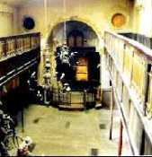
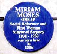
19 Princelet Street. This has the same appearance as the other Huguenot houses in the street dating from the early 1700s. However in 1870, a group of working class Russian/Polish Jews who had formed a Friendly Society purchased the building and added a Synagogue in the back garden and used it to hold Orthodox Jewish services. The building is now occupied by The Museum of Immigration. The central reading desk has been removed, but the Ark, the ladies gallery and many of the old inscriptions and fittings still remain, preserving some of the atmosphere of the original synagogue. The building is open for visits on several days in each year, details can be found at www.19princeletstreet.org.uk On the wall of the next door house is a blue plaques stating that in 1886 Miriam Moses was born here. Miriam Moses devoted her life to Social Work. In the Jewish community she was the Warden of the Brady Clubs and Settlement for many years, where she was largely responsible for the club's immense success. The building is now occupied by the Brady Arts Centre. She is remembered there by an inscription on the front of the building. She was a magistrate and served on the local council for many years, being the first woman to be mayor of Stepney. (For other Jewish sites please see Jewish East End Today and Old Jewish Synagogues and Cemeteries ) (For Princelet Street Synagogue see No. 17. on Map) |
||
 |
"Rebellion". |
|
East India House, 109-111 Pettycoat Lane (Middlesex Street). Pettycoat Lane was the original name of the street because it was a second hand clothes market from the early 1600s. In the 1830s the was changed to Middlesex Street because underclothes became "unmentionables". Beware, you might pass this by without noticing it, unless you look upward. It is nine stories up on top of tall tower at the rear of the building. (See No. 18. on Map) Sculptor: Judy Boyt. 1993. |
||
 |
Roundels. |
|
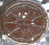
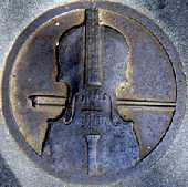
Decorative coalhole cover in front of 6 Princelet Street. Before London became a smokeless zone, coal and coke used to be delivered by coal merchants in horse-drawn carts. The sacks of coal were emptied down these holes into the coal cellars below. The reason for this design is that a previous building on this site was a Yiddish theatre. A tragedy occurred here in 1888, when someone cried "Fire" in the middle of a performance. In the rush for the exits, 17 people died in the crush. There are 24 other roundels in the Spitalfields area. On this website, five are the sites are mentioned :
Designer: Keith Bowler. 1995. |
||
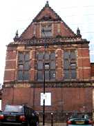 |
St. Botolph's Hall. |
|
Spital Square. This hall was built in the 1890s as part of a group of buildings used by the Central Foundation School for Girls. After the school moved out it was used by St Botolph's as a church hall. (See No. 20. on Map) |
||
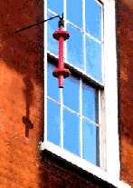 |
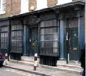
Severs House. |
|
18 Folgate Street. The Huguenot silk weaver's house has been carefully restored and filled with period fittings and furniture, even to the extent of being lit by candles rather than electricity. Arrangements can be made for visiting but this is certainly not free. The bobbin hanging outside was often used by weavers to advertise themselves in the same manner as hairdressers used a barber's pole and pawnbrokers hang three balls. (See No. 21. on Map) |
||
 |
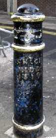
Shoreditch Borough Street Lamp. |
|
On the corner of Brushfield Street and Gun Street. This lamp post is dated 1903 and has on it the initials S B E S, which probably stand for Shoreditch Borough Electric (Light) Station in Coronet Street, N1. Further down Brushfield Street, over the parish border, the lamps have a similar shaped design but with the initials B W W D on them which stands for the Board of Works Whitechapel District. Shoreditch had become a borough in 1900 and adopted the motto of More Light More Power from this generating station, which used to burn rubbish to produce steam which in turn drove the electric generators. This is an interesting solution to London's refuse problems, but it must have contributed to the pollution which caused the notorious London fogs. In 1965, the Shoreditch Borough ceased to exist and became part of the Borough of Hackney. (See No. 22. on Map) |
||
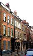  |
Silk Weavers' Houses. |
|
Fournier Street has a French name and many original Huguenot houses dating back to the early 18th century. Some of these have elaborately decorated doorways and shuttered windows. The doorway of number 8 includes ears of corn, which symbolize hospitality. This richly decorated doorway does not give a true picture of the conditions of the average silk worker. Their lives were not as smooth as the silk which they were weaving. In the early 1700s, imports of calico and cheap silks by the East India company made a number of Spitalfields silk workers unemployed. Some resorted to attacking women in the street wearing calico and tearing their dresses. In 1721, Parliament passed a law prohibiting the wearing of printed calico, but this was often ignored and was eventually withdrawn. (See No. 23. on Map) |
||
 |
Old Shop & Pre-Tolpuddle Martyrs. |
|
56-58 Artillery Lane. A remarkable survival of an old shop front dating from 1756. The buildings were occupied by two prosperous Huguenot silk merchants, Nicholas Jourdain and Francis Rybot. The shops were built at a time when Britain and France were at war, imports of French silk ceased and the Spitalfields silk trade was flourishing. But after the end of the war, in 1763, there was again unemployment and suffering amongst the silk workers, so that soup kitchens had to be opened to stop them from starving. In 1769 some silk workers met in the "Dolphin" alehouse (probably in Dolphin Close which once ran off Artillery Lane directly opposite these shops), as a mutual benefit society collecting money for self support in times when they were out of work. Employers saw this as a plot to force up wages. A unit of soldiers was sent to the alehouse, two of the workers were shot in the struggle that ensued, several more were injured and four were arrested. Two of the latter, John Doyle and John Valine, were tried for riotous behaviour and hanged in front of the Salmon and Ball pub in Bethnal Green. In their last words on the scaffold, both men said that they were innocent and Doyle said that they would not have been found guilty, if someone had not paid money to obtain false witnesses. The crowd agreed. They jeered at the officials and eventually pulled down the gibbet after the hanging. All this took place 65 years before the Tolpuddle martyrs. (See No. 24. on Map) |
||
 |
Soup Kitchen for The Jewish Poor. |
|
Brune Street. Set up to feed the poor Jewish immigrants who had fled from Tsarist Russian persecution and pogroms following the anti-Semitic May Laws in the 1880s. Over the main door is a sculpture showing a large soup tureen, and below this is the Jewish year date and the Gregorian year of the opening of the building. If one only reads the inscriptions to the left of the date, they read: "Way Out Soup Kitchen."; but in 1902 this would not have raised a smile. The building has been subdivided to make flats. (See No. 25. on Map). Brune Street is named after Walter de Brune who in 1197 founded the priory of St Mary, Spital (Hospital), which in turn caused the area to be called Spitalfields. Just off Brune Street is Tenter Ground. A Tenter ground was an area where dyed cloth was hung when drying on frames called tenters. This gave rise to the phrase "to be on tenter hooks". Later, when the homeless used to sleep there, some of the local people called the area Itchy Park, but others used to refer to the area round Christ Church by that name. (For other Jewish sites please see Old Jewish Cemeteries and Synagogues. and Jewish East End Today.) Architect: Lewis Solomon. 1903. |
||
 |
"Spitalfields Journey" |
|
Bishop's Square. A steel structure which shows photographic details of architectural features in Spitalfields. It is in two parts and is designed to be walked through. The mirrored surfaces "enable the viewer to be reflected and thus become part of the street scene". (See No. 26. on Map) Artist: David Rhys Jones, 2008. |
||
 |
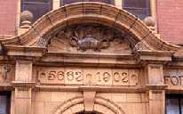
Spitalfields Market Gates. |
|
Unusual design of gates to Spitalfields market, Commercial Street entrances. A charter was issued by Charles II for a market at Spitalfields in 1682. This market specialised in fruit and vegetables. The present building was erected in 1928. The fruit and vegetable market moved to Leyton, E10, in 1986. Before that time, there were colourful displays of fruit and vegetables overflowing onto the pavements of Commercial Street. Commercial Street itself is fairly recent. It dates from 1843. As its name implies, it was constructed to take commerce to and from the newly-built docks. (See No. 27. on Map) Designer: (?) Date (?) |
||
 |
Spitalfields Market . |
|
Decorative designs on the Gable ends in Lamb Street. These examples show the picking of fruit and flowers, because this is what Spitalfields market was famous for. The area was called Spitalfields because the fields here belonged to the old St Mary's Hospital founded in 1197, which stood nearby. (For the recently excavated mediaeval remains see The Charnel House.) The area had previously been used by the Romans as a burial ground. There is an interesting Roman coffin, which was found here and is now in the Museum of London. (See No. 28. on Map) Designer: (?) Date (?) |
||
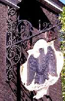 |
Truman's Brewery. | |
Black Eagle Brewery, Brick Lane. Truman, Hanbury and Buxton & Co were once one of the largest employers in the area. Founded in 1679, the brewery was sited here, because breweries were not permitted within the city walls because of the smells they produced. The brewery closed in 1988. and the area is now used by numerous art, fashion and catering concerns. Both Hanbury and Buxton are remembered by posterity by having local streets named after them. Ben Truman was given no street but received a knighthood. Note the roundel set in the pavement outside the brewery, which shows a design of tankards. (For the Brewery see No. 29. on Map See also Roundels ) Designer of roundel: Keith Bowler. 1995. |
||
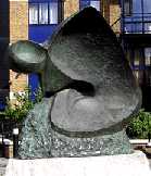 |
"Vortex" |
|
In Lamb Street opposite the side entrance of Spitalfield Market. This is not to be confused with another statue with the same name in Goodmans Square. (For this sculpture see 30. on Map) Sculptress: Barbara Sandler. 1999. |
||
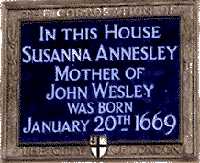 |
Wesley's Mother. |
|
The end of Spital Yard, off Spital Square. (See under Soup Kitchen for the name Spital.) A plaque marks the birthplace of Susanna Wesley (1669 � 1742), nee Annesley, who was the mother of both John and Charles Wesley. They were a numerically impressive family. Susanna the daughter of a Puritan family married Samuel Wesley an Anglican minister in Lincolnshire. She bore him nineteen children. Few of whom survived infancy; but John and Charles went on to found Methodism. John, the preacher, travelled 250,000 miles and preached 40,000 sermons, while his brother Charles wrote 5,500 hymns including "Hark, the Herald Angels Sing." (See 31. on Map) |
||

OTHER AREAS COVERED:-
|| Beckton || Bethnal Green || Blackwall || Bow || Bromley-by-Bow || Canary Wharf || Canning Town || Chingford || Cubit Town || Custom House || East Ham || East India Dock || Forest Gate || Higham's Park || Leyton || Leytonstone || Limehouse || Little Ilford || Manor Park || Mile End || Millwall || North Woolwich || Plaistow || Plashet || Poplar || St George's || St Katharine Dock || Shadwell || Shoreditch || Silvertown || Snaresbrook || Stepney || Stratford || Upton || Walthamstow East || Walthamstow Village || Walthamstow West || Wanstead || Wapping || West India Dock || Woodford || Whitechapel || |