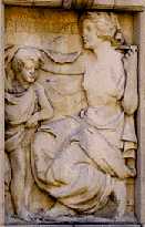
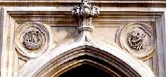
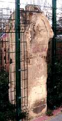
Atkinson Memorial.
At the junction of Stepney Green and Redmans Road. This Clock Tower and monument was moved here from a site in Burdett Road. The illustration shows a relief on the side of a monument to the memory of Stanley Bean Atkinson (1873-1910), who was a member of the Medico-Legal Society specializing in both medicine and law, a JP and a prominent local councillor. He is remembered for the communal, educational and welfare work, hence the two designs on the base. This represents "Benevolence" and the other "Education". There is a portrait bust of Atkinson in the Bancroft Road Library. (See No. 1. on Map)
Sculptor: Gilbert Seale. 1913.
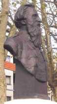
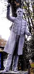
William Booth Statues.
Mile End Waste, Mile End Road, E1. There are two statues of William Booth the founder of the Salvation Army, who began his preaching here. In 1865, he began near to the Vine Tavern, a wooden building dating back to Stuart times. The area was common ground and known as Mile End Waste. In 1903, Stepney Council took over the waste, pulled down the old pub and put the low fence posts round the grassy areas which can be seen today.
Right. Full size statue showing Booth preaching. The outstretched hand is far from original. On many occasions it has had to be replaced after someone had broken it off and stolen it. This statue is a copy, the original is in south London. (See No. 2. on Map )
Sculptor: George Edward Wade. Erected 1979.
Left. Bust showing him as he was when older. (See No. 2. on Map )
Sculptor: George Edward Wade, 1927. (See also Queen Alexandra Statue by the same artist)

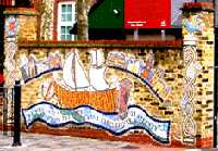
Cayley School Mosaic .
Aston Street, which runs just behind St Dunstan's Church. The mosaic features a sailing ship and includes the saying:
Is a parishioner of Stepney
Captain Cook .
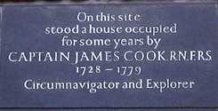
No, 88 Mile End Road. This shows the site where Captain James Cook (1728-1779) used to live. However the house was allowed to be demolished. The illustration shows just part of the large commemorative inscription that is set in a brick wall, behind which is a private car park. Cook probably chose to live here because it was in easy walking distance of the Thames and yet in semi-rural surroundings. (For another sea captain who did the same see also Captain Bligh. The Royal Navy sent Cook on voyages of exploration and surveying which took him literally around the globe. He charted Newfoundland, New Zealand, the East Coast of Australia, parts of Antartica and the West coast of North America. He was eventually killed by natives in Hawaii, while trying to recover a ships boat they had stolen. (See No. 4. on Map )
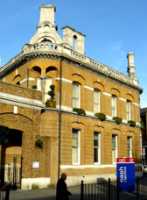
Charringtons Anchor Brewery.
Mile End Road. Previously the main offices of Charrington's Brewery, but now occupied by group of solicitors. None of the other buildings of the brewery, which occupied the surrounding area from 1757, now survive. While most of the Charrington family were trying to sell as much beer as possible, Frederick Charrington was the white sheep of the family, and in the late nineteenth century led a campaign against the evils of drink. (See No. 5. on Map )
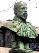
King Edward VII .
On Mile End Waste in front of 39 Mile End Road. Bust of King Edward VII who was the son of Queen Victoria. He ascended the throne at the age of 60 and only reigned 11 years (1901 � 1911). The inscription under the bust reads:
|
Erected by a few freemasons of the Eastern District of LONDON 1911. |
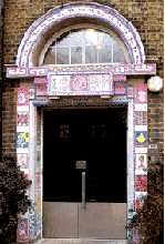
Inclusion Support Centre.
Tower Hamlets Inclusion Support Centre, Globe Road. The mosaic doorway contains various brightly coloured designs which are religious, secular or from folklore. (See No. 7. on Map )
Artist: Teena Gould (?)
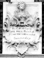
Mercers' Cottages.
Whitehorse Lane. The original almshouses were donated and built in 1691. The donor was Dame Jane Mico, described as "the relict of Sir Sam Mico, mercer." Relict was the term often used to describe a widow. The cottages were rebuilt by the Mercers' Company in 1856 on part of a large tract of land owned by the company. The Mercers' Company had obtained the property in the 16th century from the estate of John Colet (mentioned under Stepney Meeting.) It also explains why the pub round the corner is called the Mercer's Arms. The female figure at the top is an early "trademark" of the Drapers Company. The lady was said to be "gentle Queen Agnes", supposedly sister of Thomas Becket. (Or was she just a good customer of the drapers?) In the late 20th century, the Company merged the charity responsible for these houses with that of the Sir Richard (Dick) Whittington almshouses in Highgate. There is no mention in the charity documents to the cat, who tradition says was responsible for Sir Richard's great wealth. (See No. 8. on Map)
Sculptor Jasper Latham ? date 1691.
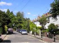
Mile End Place.
Hidden away down an alley between 241 and 245 Mile End Road. These attractive terraces of 19th century workers cottages are in marked contrast to the rest of the surrounding East End. (See No. 9. on Map)
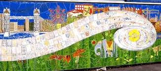
Ocean School Mural.
Ben Jonson Road. Part of a large mural composed of ceramic tiles an outside wall of the school. Many of the tiles were designed by pupils of the school and their names are usually displayed on the tiles, which are laid out in a flowing line representing the river Thames. The project is entitled "Ocean New Deal for Communities." (See No. 10. on Map) The road is named after Ben Jonson (1572-1637) dramatist and contemporary of Shakespeare, who acted in at least one of Jonson's plays at the Curtain Theatre. (See also St Leonard's (Actors) Church)
Date 2002.
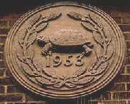
Peter Shore Court.
Along the East side of Beaumont Square. A residential home for the elderly. Over the door there is a tortoise flanked by two parakeets. Presumably, this emblem was chosen to reflect longevity rather than the speed of movement of the residents. Peter Shore (1924-2001) was MP for Stepney and became a cabinet minister. Beaumont Square is named after Barber Beaumont (1774-1841) who founded the Provident Life Friendly Society. He founded the New Philosophical Institute in the square. After his death the trust from his estate together with the Drapers Company helped to found the People's Palace and the Technical College which became Queen Mary & Westfield College in Mile End Road. (See No. 11. on Map)
Date 1953.
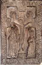
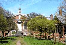
St Dunstan's Church.
Whitehorse Lane. This is Stepney parish Church and dates back to the tenth century. Dunstan (c. 909 - 988), was made Bishop of Worcester then of London and finally Archbishop of Canterbury in 961. He is reputed to have pinched the devil's nose with iron tongs, hence the carving on the right hand side over the doorway into the church. The ship on the left is there because this was the sailor's church, and the red ensign, the flag of the merchant navy, can often be seen flying from its flagpole. (See also Cayley School Mosaic.) In times past, a light used to be lit in its tower to help guide ships into the port of London.
Inside the church, at the eastern end, there is a carving of the crucifixion which is thought to be Saxon, dating back to the 10th century. (See No. 12. on Map)
Albert Stern House.
253 Mile End Road. Now used as residential accommodation by Queen Mary College, this was built as a home for elderly Sephardi Jews (originating from Spain and Portugal). There are commemorative and historical inscriptions on the front of the house. Behind this building is the oldest Jewish cemetery in Britain. Purchased in 1657 after Oliver Cromwell permitted Jews to return to England 267 years after they had been expelled by King Edward I. (For other Jewish sites please see Jewish East End Today and Old Jewish Synagogues and Cemeteries ) (For Albert Stern House see No. 13. on Map)
Stepney Jewish School.
Stepney Green. The monogram SJS for the Stepney Jewish School is still on the original wrought iron gate, dating back to 1906. The much of the school buildings are also there, but the school has now moved to the Ilford area. The buildings are now used for artists' studios. Behind the school used to be the site of the London Jewish Hospital, which is now occupied by the London Independent Hospital. (See No. 14. on Map)
See also Jewish views on Education.
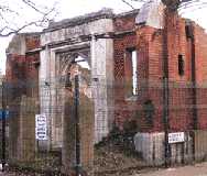
Stepney Meeting.
Stepney Way. This is a small fragment of the frontage of the Congregational Chapel that survived the bombing, and now forms part of the perimeter fence of Steppingstones Farm. A large part of the back wall can be seen inside the farm. (Visitors welcome) Stepney Meeting was the first independent church in East London and was founded in 1644. The congregation still survives and after merging with another one is now the Stepney Meeting House Reformed Church near the junction of Stepney Way and Jubilee Street. The whole area of the farm is shown on 19th century maps as King John's Palace. This is one of two places in the area with this title. The other is at Old Ford. This one was previously called Worcester House, which was probably built on the site of the old moated manor house owned by Henry le Waleis where parliament once sat. This occurred in 1299, after a fire had damaged Westminster Hall. This house was later owned by Sir Henry Colet, twice Lord Mayor of London, and then by his son John Colet minister of St Dunstan's Church later Dean of St Pauls and founder of St Paul's School. The next occupant of the house after him was Thomas Cromwell, who succeeded Cardinal Wolsey as chief minister to Henry VIII. (See No. 15. on Map)
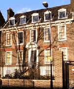
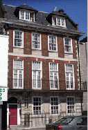
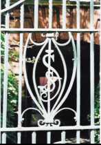
37 Stepney Green.
This imposing Queen Anne house was built in 1692. The iron railings are of particular interest. The monogram over the gate appears to contain the letters M and G. This probably stands for Mary Gayer, the widow of a Mayor of Bombay (Mumbai). She occupied the house in 1714. This house clearly reflects a period when Stepney was a more prosperous area. (See No. 16. on Map)
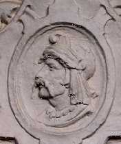
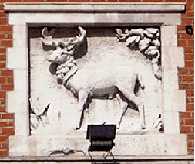
Stepney Green Court.
Stepney Green. This block of flats was built in 1896 by the 4% Industrial Dwellings Company. This Jewish company chaired by Nathaniel, Lord Rothschild set about building good quality but low rent accommodation for the working poor of the East End. The profits for shareholders were limited to 4%. This head is on one of the series of decorative stone panels which embellish the front of the buildings. Each has a different classical style head. Could this one with the handle-bar moustache be intended to be Vercingetorix (the Gaul who led a revolt against Julius Caesar) ? The others appear to be Greek or Roman. These were some of the earliest buildings in the East End to supply hot water on tap to the residents. (See No. 17. on Map)
Architect: N.S. Joseph.
Trinity Almshouses.
Trinity Green, Mile End Road. These handsome almshouses were built to house "decayed masters and commanders of ships and their widows" as mentioned on the two original plaques on either side of the entrance gates. The "decay" mentioned was that of the old mariners' finances rather than of their flesh. There are two models of three-masted sailing ships on the front wall which are interesting. (See No. 18. on Map) The man responsible for organising the project was Capt. Henry Mudd, whose grave can be found in St Dunstan's churchyard, covered by a newly carved stone.
The adjacent building, the Tower Hamlets Mission, stands on the site of the Great Assembly Hall built by Frederick Charrington in 1886. Charrington a prominent member of the family that owned the Brewery still standing just up the road. He suddenly turned to religion, and campaigned vigorously against drink and other vices.
Builder:William Ogbourne. 1695.
Ships' Sculptor: Robert Jones.
Unitarian College Chapel.
On the corner of Garden Street and Stepney Green. The entrance to this chapel was preserved after the second World War, when the rest of the building was destroyed in an air raid. The remnant of the chapel is now being used by Steppingstones Farm for a storage area. The green of the farm and the adjacent park remind us that Stepney used to be a country village in the midst of a green area known as Bow Common which stretched as far as Mile End Old Town. It was here that in 1381 the men of Essex and Kent gathered under the leadership of Wat Tyler to protest at the burdensome Poll Tax. The fourteen-year-old King Richard II came here and met the protesters. In the presence of such a large protest, he appeared to agree to their demands; but the next day at a second smaller meeting in Smithfield, Wat Tyler was provoked to anger, which gave an excuse for arresting the leaders, who were later beheaded. (For more on the previous use of this site see Congregational Church. and for position see No. 19. on Map)
The White Hart.
At the corner of Cambridge Heath Road and Whitechapel Road. This pub has its sign carved on to the wall. The present pub dates from about 1900, but it replaced an older building with the same name, which dated back to the eighteenth century. (See No. 20. on Map)